Advertisement
Latest Version (Download)Table of Contents
Advertisement
Information
| Package | de.realitymaps.alpen |
| Version | 0.1.9.190430 |
| Date Updated | 2021-01-31 |
| Size | 67.58 MB |
| Installs | 70 |
| Categories | , |
Screenshots


Description
Guide for hiking, mountaineering and biking
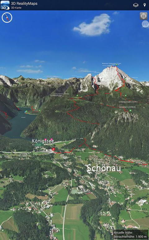
Only 3D Outdoor Guides’ unique app showcases the most attractive regions of the Alps in photorealistic 3D. Each region comes complete with carefully-selected tour recommendations (Bergverlag Rother), digitized trails and elevation profiles for hiking, mountaineering and mountain biking.
3D displays built from fine-resolution aerial images reveal the most intricate details in the landscape, enabling users to form a realistic impression of the terrain, ascents and trails. With this technology, even remote locations such as isolated alpine lakes, alms or unknown peaks – sometimes overlooked by traditional maps – are yours to discover.
The app’s GPS technology and 3D display simplifies orientation outdoors. The user’s current position is always shown on the 3D map, confirming present location and indicating the way ahead.
All geographic information and tours are precisely located on the map and offer additional information such as opening times and webcam photos showing current conditions on-site.
To avoid issues with internet connectivity in the mountains, our 3D maps and all their geographic information can also be saved directly to your mobile device.
When recording tours, our advanced tracking tool provides trail statistics such as speed, distance covered and elevation.
Looking for even more tours? Download as many GPX tracks as you like from external sources and import them to the app with a click!
Features at a glance:
- Photorealistic 3D maps derived from aerial images
- Offline maps offering constant, reliable access, even without the internet
- Topographic map with a scale of 1:25.000
- More than 3000 tours selected by mountain experts, including route displays, descriptions, and elevation profiles
- Current location displayed using GPS technology
- Precise recording of personal tours and trail statistics (speed, elevation, distance and duration)
- Integrated GPX import
- Virtual panorama
- Komoot compatibility: import your tracks directly to the app
The free version of the app gives users access to all our 3D maps when online. If you want to use the maps offline and unlock all our premium features, you need to opt into one of our subscriptions (7 Days: 4.99 €, 1 Month: 9.99 €, 1 Year: 39.99 €). Subscriptions are managed by Google Play Store and can be cancelled there at any time.
Spatial coverage: currently, over 80 regions are available across the Alps – from the Zugspitze to the Dolomites, and Berchtesgaden Alps to the Matterhorn, everyone is bound to discover their favourite region in 3D!
Remark: Continued use of the GPS can decrease battery life.
What's New
General improvements.
Latest Version (Download)
3D Outdoor Guides 0.1.9.190430Date Updated : 2021-01-31
Advertisement
