Advertisement
Latest Version (Download)Table of Contents
Advertisement
Information
| Package | org.project.geoclass |
| Version | 3.5.4 |
| Date Updated | 2023-01-17 |
| Size | 51.89 MB |
| Installs | 44 |
| Categories | Ứng dụng, Công cụ |
Screenshots


Description
Một ứng dụng khảo sát đất thực tế.
Surveying Calculator has commonly used land surveying tools. This includes coordinate geometry calculations, offline point data collection, displaying CAD, GIS, raster data and online maps in QGIS 3 project format. Surveying Calculator supports QGIS 3 projects. (qgs, qgz)
Features:
- Jobs:
→ Create unlimited jobs for collecting points in SHP or GeoPackage formats with coordinate system code (EPSG code).
→ You can also prepare a job in QGIS on desktop with geospatial data. Import CAD, GIS, raster data or add online map services in QGIS. And transfer the data folder to Surveying_Calculator/projects folder on your device. Select the project in Jobs and Start Survey.
- Start Survey:
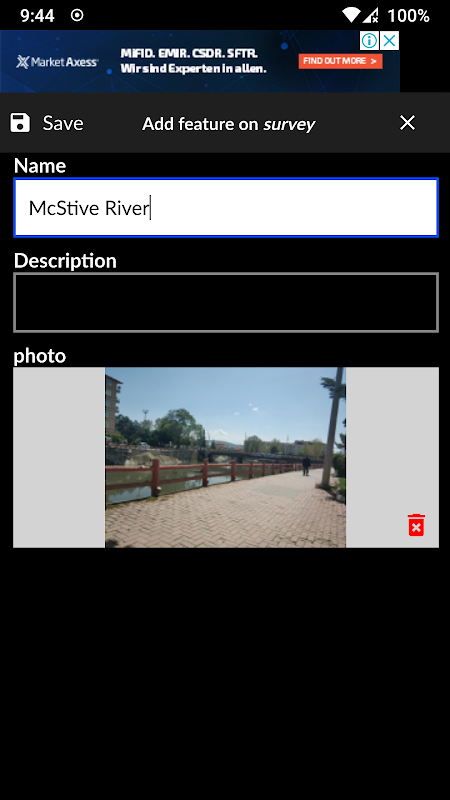
→ Collect unlimited points with "name" and "description". You can record your location or any place you want.
→ Add point with coordinates ( x, y or latitude, longitude).
→ Make surveying easy using QGIS projects.
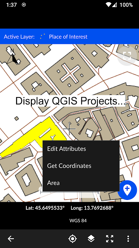
- Map Viewer: Displays QGIS 3 projects.
→ It is possible to include geospatial data to display maps on this app;
→ Raster (GeoTIFF, DEM, JPEG, PNG, GRD, XYZ, ..),
→ CAD (DXF, DGN v7),
→ GIS (ArcGIS shp, Google Earth (kml, kmz), GeoJSON, GPX..),
→ Online map services (Open Street Maps, Hybrid Maps, Satellite Maps, Terrain Maps..) Online maps can be prepared using QuickMapServices plugin in QGIS. You can add Open Street Maps, hybrid or satellite maps in QGIS project for Surveying Calculator.
→ Geodatabase (GeoPackage, Spatialite) formats in QGIS projects.
- Coordinate System support:
→ Supports 5000 different EPSG coordinate systems.
→ User can search a coordinate system with country name or coordinate system name on epsg.io site. And user can create jobs with a proper EPSG code.
→ The coordinate system can be projected ( in feet or meters units) or geographic (in degree)
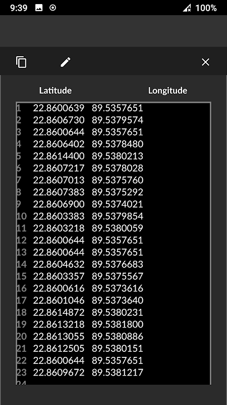
- Generate Coordinates: Generate coordinates in latitude/ longitude or in X, Y.
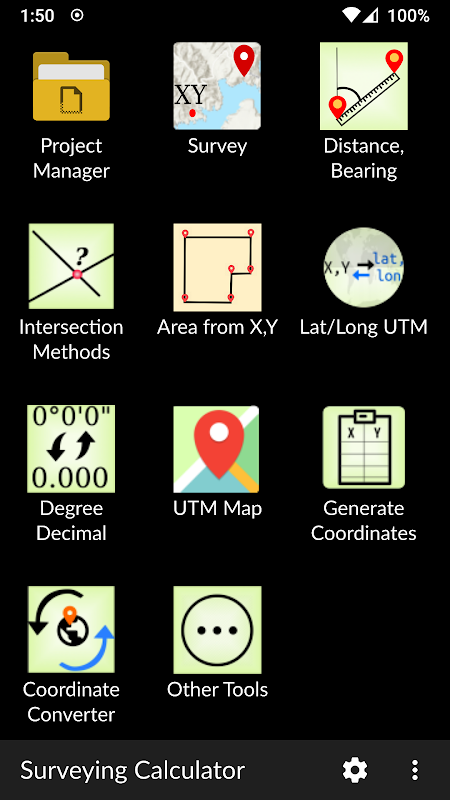
- Basic Surveying Tools: X(N), Y(E) Calculation, Distance, Azimuth Calculation, Interior Angle, Latitude Longitude from point, distance and bearing
- Intersection Methods: Forward Intersection, Line - Line Intersection, Circle by 3 Points
- Distance between Coordinates: 2D, 3D distance from X, Y and distance from Latitude, Longitude
- Area calculation from coordinates
- Degree - Decimal Conversion
- Coordinate Converter: WGS84 Latitude/Longitude to UTM XY or UTM XY to Latitude/Longitude Conventer, 2D Helmert transformation
- Settings: Coordinate order of northing, easting or latitude, longitude. DMS or decimal options for geographic coordinate systems. Scale bar unit settings in metric or imperial.
- and more.
Surveying Calculator supports Android 6.0 and up. Minimum 2GB RAM with 300MB free space are recommended.
Some of the new modules have bugs with the new update:
- Start Survey: The app sometimes closes unexpectedly when GPS button is active. To prevent this problem, turn off GPS mode before exiting Start Survey.
- Scale bar sometimes gives wrong results after adding layers and storing points.
- Projects sometimes display rotated map on Start Survey and Map View.
- Points are sometimes not recorded in Geopackage format.
It is planned to fix the weird bugs for next updates.
If you need help or if you have any suggestion about this app please mail to [email protected] or join Surveying Calculator Facebook group to ask questions. You can follow news about the app on Facebook Page:
fb.me/surveyingcalculator
Máy tính khảo sát đã sử dụng các công cụ khảo sát đất thường được sử dụng. Điều này bao gồm phối hợp tính toán hình học, thu thập dữ liệu điểm ngoại tuyến, hiển thị CAD, GIS, dữ liệu raster và bản đồ trực tuyến ở định dạng dự án QGIS 3. Máy tính khảo sát hỗ trợ các dự án QGIS 3. (qss, qgz)
Tính năng :
- Công việc:
& rarr; Tạo công việc không giới hạn để thu thập điểm ở định dạng SHP hoặc GeoPackage với mã hệ thống tọa độ (mã EPSG).
& rarr; Bạn cũng có thể chuẩn bị một công việc trong QGIS trên máy tính để bàn với dữ liệu không gian địa lý. Nhập CAD, GIS, dữ liệu raster hoặc thêm dịch vụ bản đồ trực tuyến trong QGIS. Và chuyển thư mục dữ liệu sang thư mục Surveying_Calculator / dự án trên thiết bị của bạn. Chọn dự án trong Jobs và Bắt đầu khảo sát.
- Bắt đầu khảo sát:
& rarr; Thu thập điểm không giới hạn với "tên" và "mô tả". Bạn có thể ghi lại vị trí của bạn hoặc bất kỳ nơi nào bạn muốn.
& rarr; Thêm điểm với tọa độ (x, y hoặc vĩ độ, kinh độ).
& rarr; Làm cho khảo sát dễ dàng bằng cách sử dụng các dự án QGIS.
- Trình xem bản đồ: Hiển thị các dự án QGIS 3.
& rarr; Có thể bao gồm dữ liệu không gian địa lý để hiển thị bản đồ trên ứng dụng này;
& rarr; Raster (GeoTIFF, DEM, JPEG, PNG, GRD, XYZ, ..),
& rarr; CAD (DXF, DGN v7),
& rarr; GIS (ArcGIS shp, Google Earth (kml, kmz), GeoJSON, GPX ..),
& rarr; Các dịch vụ bản đồ trực tuyến (Bản đồ đường phố mở, Bản đồ lai, Bản đồ vệ tinh, Bản đồ địa hình ..) Bản đồ trực tuyến có thể được chuẩn bị bằng cách sử dụng plugin QuickMapService trong QGIS. Bạn có thể thêm Bản đồ đường phố mở, bản đồ lai hoặc vệ tinh trong dự án QGIS cho Máy tính khảo sát.
& rarr; Các định dạng Geodatabase (GeoPackage, Spatialite) trong các dự án của QGIS.
- Hỗ trợ hệ thống tọa độ:
& rarr; Hỗ trợ 5000 hệ thống tọa độ EPSG khác nhau.
& rarr; Người dùng có thể tìm kiếm một hệ tọa độ với tên quốc gia hoặc tên hệ thống tọa độ trên trang web epsg.io. Và người dùng có thể tạo công việc với mã EPSG thích hợp.
& rarr; Hệ tọa độ có thể được chiếu (theo đơn vị feet hoặc mét) hoặc địa lý (tính theo độ)
- Tạo tọa độ: Tạo tọa độ theo vĩ độ / kinh độ hoặc theo X, Y.
- Công cụ khảo sát cơ bản: X (N), Y (E) Tính toán, Khoảng cách, Tính toán phương vị, Góc bên trong, Kinh độ vĩ độ từ điểm, khoảng cách và phương hướng
- Phương thức giao nhau: Giao lộ chuyển tiếp, Giao lộ đường thẳng, Vòng tròn bằng 3 điểm
- Khoảng cách giữa các tọa độ: 2D, khoảng cách 3D từ X, Y và khoảng cách từ Vĩ độ, Kinh độ
- Tính diện tích từ tọa độ
- Bằng cấp - Chuyển đổi thập phân
- Bộ chuyển đổi tọa độ: WGS84 Vĩ độ / Kinh độ cho UTM XY hoặc UTM XY sang Conventer Vĩ độ / Kinh độ, chuyển đổi Helmert 2D
- Cài đặt: Phối hợp thứ tự về hướng bắc, hướng đông hoặc vĩ độ, kinh độ. DMS hoặc tùy chọn thập phân cho các hệ tọa độ địa lý. Cài đặt đơn vị thanh tỷ lệ theo số liệu hoặc đế.
- và hơn thế nữa.
Máy tính khảo sát hỗ trợ Android 6.0 trở lên. Nên sử dụng RAM tối thiểu 2GB với dung lượng trống 300MB.
Một số mô-đun mới có lỗi với bản cập nhật mới:
- Bắt đầu khảo sát: Ứng dụng đôi khi đóng bất ngờ khi nút GPS hoạt động. Để ngăn chặn sự cố này, hãy tắt chế độ GPS trước khi thoát Bắt đầu khảo sát.
- Thanh tỷ lệ đôi khi cho kết quả sai sau khi thêm lớp và lưu trữ điểm.
- Các dự án đôi khi hiển thị bản đồ xoay trên Bắt đầu khảo sát và Chế độ xem bản đồ.
- Điểm đôi khi không được ghi ở định dạng Geopackage.
Nó được lên kế hoạch để sửa các lỗi kỳ lạ cho các bản cập nhật tiếp theo.
Nếu bạn cần trợ giúp hoặc nếu bạn có bất kỳ đề xuất nào về ứng dụng này, vui lòng gửi thư đến [email protected] hoặc tham gia nhóm Facebook Surveying Calculator để đặt câu hỏi. Bạn có thể theo dõi tin tức về ứng dụng trên Trang Facebook:
fb.me/surveyingcalculator
What's New
- Added Jobs, Start Survey, Map View and Coordinate Generator modules.
- Able to add jobs in SHP or GeoPackage formats
- Able to store unlimited points in SHP or GeoPackage formats. Almost all coordinate systems supported in the world (5000+ EPSG coordinate systems support)
- Support for displaying the formats: Rasters (GeoTIFF, DEM, JPEG, E00, GRD...), CAD (DXF, DGN), GIS (SHP, KML, KMZ, GML, GPX, GeoJSON...), and Geospatial database (GeoPackage, Spatialite)
- Updated Settings
Latest Version (Download)
Surveying Calculator 3.5.4Date Updated : 2023-01-17
Advertisement
