Advertisement
Latest Version (Download)Table of Contents
Advertisement
Information
| Package | no.avinet.norgeskart |
| Version | 3.16.8 |
| Date Updated | 2022-03-06 |
| Size | 11.23 MB |
| Installs | 876 |
| Categories | , |
Screenshots


Description
Các bản đồ đi bộ đường dài tốt nhất cho Na Uy. TellTur, GodTur, GPS, tuyến đường, ghi âm theo dõi
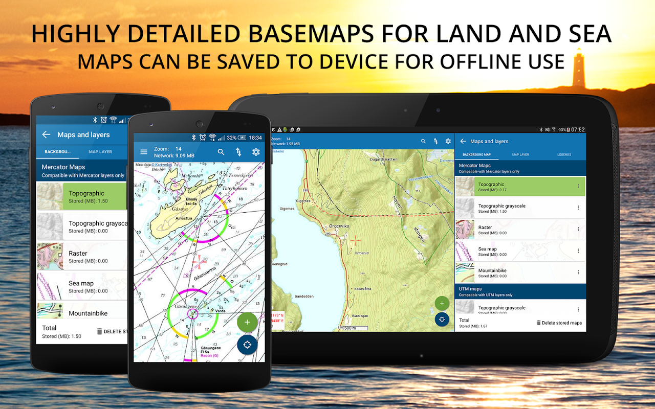
Norgeskart Outdoors has all what you need for hiking, biking, boating or skiing. Everything can be made available for offline use without mobile coverage. Includes topographically maps for Norway, Svalbard, Jan Mayen and Sweden. Now also with altitude (depth at sea) and place name for any given location in Norway!
The app was first launched in 2010 under the name Norgeskart, but changed its name to Norgeskart Outdoors in 2018. It is among the most popular hiking and map apps in Norway. Much has happened since it was first launched and there is still a lot to come!
Plan your next trip by downloading tours and descriptions directly in the app from TellTur and GodTur. Everything available regardless of mobile coverage. For Telltur you can register with the app when you arrive at a destination and compete with others to visit most places. You can easily find current trips by filtering and sorting the list of hiking destinations from your location or center of the screen.
Explore exciting archaeological discoveries, cultural monuments, architecture, stories etc. near where you are. This exciting content is taken from the Norwegian Arts Council's Norvegiana database of cultural data from archives, museums and other cultural institutions.
Register points of interest (POIs), routes and record GPS tracks. These can, if desired, be written to GPX files or uploaded to norgeskart.avinet.no. You can then look at your own data in the browser and easily transfer between phones and tablets. In the app you can also read content from GPX files that you find on ut.no or from other sources.
This app contains both free and paid content (see complete overview below). By paying for a subscription, you support the further development of the app and take full advantage of all the exciting things we have to offer.
Free content:
------------------
- Topographical and nautical maps for Norway, Svalbard and Jan Mayen
- Altitude and place name for crosshair location in Norway.
- Search for addresses, place names and coordinates.
- Property borders and UTM grid layers
- Cultural history content from Norvegiana
- Import and export of GPX files
- GPS track recording displayed with graph display.
- Create own routes and POIs
- Compass
- Driving directions
Premium subscription:
------------------
- Topographically maps of Sweden.
- Download maps for offline use (Sweden limited to storage by panning and zooming)
- Trip suggestions from godtur.no and telltur.no
- Check in TellTur trips upon arrival at destination (free the rest of 2020 due to corona)
- Access to map portal norgeskart.avinet.no
- Upload POIs, tracks and routes
- Synchronize your data across devices
- Mountain bike routes for Scandinavia
- Pistes Alpine and Cross-country for Scandinavia
- Avalanche awareness and steepness
- Weak ice
- Snow depth and skiing conditions
- Snowmobile tracks for Scandinavia
- Sea depths
- Conservation areas
- Clay and radon
- Orienting maps from okartkiosken.no
Dynamic point subscription:
------------------
- Connect to one or more dynamically updated KML files on the internet
- Tested against telespor.no for tracking sheeps
Norgeskart Outwhere có tất cả những gì bạn cần để đi bộ, đi xe đạp, chèo thuyền hoặc trượt tuyết. Mọi thứ đều có thể được cung cấp để sử dụng ngoại tuyến mà không cần phủ sóng di động. Bao gồm các bản đồ địa hình cho Na Uy, Svalbard, Jan Mayen và Thụy Điển. Bây giờ cũng với độ cao (độ sâu trên biển) và tên địa điểm cho bất kỳ vị trí nào ở Na Uy!
Ứng dụng này được ra mắt lần đầu tiên vào năm 2010 dưới tên Norgeskart, nhưng đã đổi tên thành Norgeskart Outwhere vào năm 2018. Đây là một trong những ứng dụng đi bộ và đi bộ phổ biến nhất ở Na Uy. Nhiều điều đã xảy ra kể từ khi nó được ra mắt lần đầu tiên và vẫn còn rất nhiều điều sẽ đến!
Lập kế hoạch chuyến đi tiếp theo của bạn bằng cách tải xuống các chuyến tham quan và mô tả trực tiếp trong ứng dụng từ TellTur và GodTur. Tất cả mọi thứ có sẵn bất kể vùng phủ sóng di động. Đối với Telltur, bạn có thể đăng ký với ứng dụng khi đến điểm đến và cạnh tranh với những người khác để đến thăm hầu hết các địa điểm. Bạn có thể dễ dàng tìm thấy các chuyến đi hiện tại bằng cách lọc và sắp xếp danh sách các điểm đến đi bộ đường dài từ vị trí hoặc trung tâm của màn hình.
Khám phá những khám phá khảo cổ thú vị, di tích văn hóa, kiến trúc, những câu chuyện, vv gần nơi bạn ở. Nội dung thú vị này được lấy từ cơ sở dữ liệu văn hóa Norvegiana của Hội đồng Nghệ thuật Na Uy từ tài liệu lưu trữ, bảo tàng và các tổ chức văn hóa khác.
Đăng ký các điểm quan tâm (POI), tuyến đường và ghi lại các tuyến đường GPS. Chúng có thể, nếu muốn, được ghi vào tệp GPX hoặc được tải lên norgeskart.avinet.no. Sau đó, bạn có thể xem dữ liệu của riêng mình trong trình duyệt và dễ dàng chuyển giữa điện thoại và máy tính bảng. Trong ứng dụng, bạn cũng có thể đọc nội dung từ các tệp GPX mà bạn tìm thấy trên ut.no hoặc từ các nguồn khác.
Ứng dụng này chứa cả nội dung miễn phí và trả phí (xem tổng quan đầy đủ bên dưới). Bằng cách trả tiền cho một thuê bao, bạn hỗ trợ sự phát triển hơn nữa của ứng dụng và tận dụng tối đa tất cả những điều thú vị chúng tôi phải cung cấp.
Nội dung miễn phí:
------------------
- Bản đồ địa hình và hải lý cho Na Uy, Svalbard và Jan Mayen
- Độ cao và tên địa điểm cho vị trí crosshair ở Na Uy.
- Tìm kiếm địa chỉ, tên địa điểm và tọa độ.
- Đường viền thuộc tính và các lớp lưới UTM
- Nội dung lịch sử văn hóa từ Norvegiana
- Nhập và xuất tệp GPX
- Ghi theo dõi GPS được hiển thị với màn hình hiển thị.
- Tạo tuyến đường và POI riêng
- La bàn
- Hướng dẫn lái xe
Thuê bao trả phí:
------------------
- Bản đồ địa hình của Thụy Điển.
- Tải xuống bản đồ để sử dụng ngoại tuyến (Thụy Điển giới hạn lưu trữ bằng cách xoay và thu phóng)
- Gợi ý chuyến đi từ godtur.no và Telltur.no
- Kiểm tra các chuyến đi của TellTur khi đến điểm đến (miễn phí phần còn lại của năm 2020 do corona)
- Truy cập vào cổng thông tin bản đồ norgeskart.avinet.no
- Tải lên POI, bản nhạc và tuyến đường
- Đồng bộ hóa dữ liệu của bạn trên các thiết bị
- Tuyến đường xe đạp leo núi cho Scandinavia
- Pistes Alps và xuyên quốc gia cho Scandinavia
- Nhận thức và độ dốc
- Băng yếu
- Độ sâu tuyết và điều kiện trượt tuyết
- Đường ray xe trượt tuyết cho Scandinavia
- Độ sâu của biển
- Khu vực bảo tồn
- Đất sét và radon
- Định hướng bản đồ từ okartkiosken.no
Đăng ký điểm động:
------------------
- Kết nối với một hoặc nhiều tệp KML được cập nhật động trên internet
- Đã thử nghiệm với telespor.no để theo dõi cừu
What's New
3.12.5
- Improved TellTur check in when no mobile coverage
- Fixed download of tiles stopping if network issues.
- Fixed crash in TellTur functions after download
3.12.x:
- TellTur free the rest of 2020 due to corona
- Search for UTM and MGRS added
- Improved quality of map display
- Altitude and place name for location of crosshair
- Added coordinate search
- Added TellTur parkings
- TellTur content refreshed daily in list
- Svalbard maps made available for free online
Latest Version (Download)
Norgeskart Outdoors - Offline maps & trips Norway 3.16.8Date Updated : 2022-03-06
Advertisement
