Advertisement
Latest Version (Download)Table of Contents
Advertisement
Information
| Package | net.binaryearth.handysurveying |
| Version | 6.5 |
| Date Updated | 2021-06-02 |
| Size | 1.72 MB |
| Installs | 154 |
| Categories | Applications, Tools |
Screenshots


Description
Arazi etütleri için kapsamlı ve kullanımı kolay bir araç
This app has been developed in consultation with experienced surveyors in both Australia and the US and includes many of the common Coordinate Geometry (COGO) calculations needed for land surveying field work.
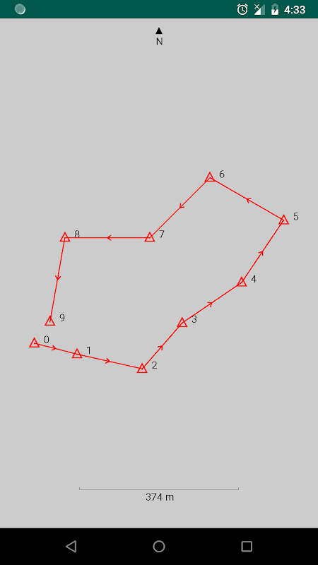
The app can store points for multiple jobs simultaneously, and can easily compute and store the next point on each leg of a continuous bearing and distance traverse. Once a traverse has been completed, it can be plotted, exported, and the misclosure can be computed and corrected if desired.
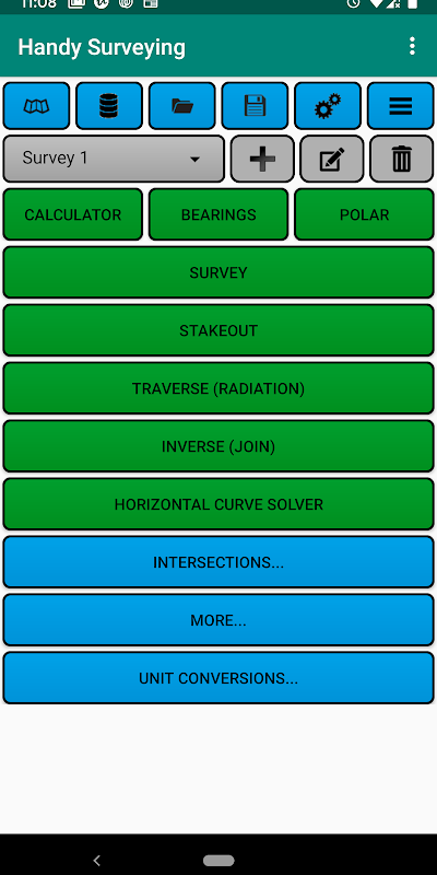
Functions include:
* Conduct a survey as a continuous traverse, automatically storing points in a point database
* Stakeout points on the ground from a plan
* Plot survey points
* List and edit survey point coordinates
* Import and export survey points from/to a CSV file
* Compute the misclosure distance and angle
* Automatically correct the misclosure using the Bowditch method.
* Compute enclosed area and perimeter
* Traverse / Radiation (2D and 3D)
* Inverse / Join (2D and 3D)
* Horizontal curve solver
* Intersection by bearings
* Intersection by distances
* Intersection by bearing and distance
* Intersection of two lines
* Intersection of perpendicular lines
* Point Scale Factor
* Grid Convergence
* General purpose calculator with trig functions and degree conversion tool
* Bearing calculator
* Polar to rectangular tool
* Units conversion tool
The app defaults to bearing entry and display in DD.MMSS format, but you can also select D/M/S or Decimal Degrees (Dec Deg) formats. You can also choose for northings to appear before eastings using an option on the preferences page.
Bu uygulama hem Avustralya'da hem de ABD'de deneyimli sörveyörlerle istişare içinde geliştirilmiştir ve arazi etüdü saha çalışması için gerekli olan ortak Koordinat Geometrisi (COGO) hesaplamalarının çoğunu içermektedir.
Uygulama, aynı anda birden fazla iş için noktaları depolayabilir ve sürekli bir rulman ve mesafe hareketinin her bacağında bir sonraki noktayı kolayca hesaplayabilir ve saklayabilir. Bir travers tamamlandığında, grafik çizilebilir, dışa aktarılabilir ve eğer istenmezse yanlışlık hesaplanabilir ve düzeltilebilir.
İşlevler şunları içerir:
* Bir noktadan bir veritabanında otomatik olarak noktaları depolayan, sürekli bir travers olarak anket yapmak
* Bir plandan yere stakeout noktaları
* Arsa anket noktaları
* Anket noktası koordinatlarını listeleme ve düzenleme
* Anket noktalarını bir CSV dosyasına / CSV dosyasına alma ve verme
* Düşük mesafe ve açı hesaplayın
* Bowditch yöntemini kullanarak yanlış kapatmayı otomatik olarak düzeltin.
* Hesaplanan kapalı alan ve çevreyi hesaplayın
* Travers / Radyasyon (2B ve 3B)
* Ters / Birleştirme (2D ve 3D)
* Yatay eğri çözücü
* Rulmanlar ile kesişme
* Mesafelere göre kesişme
* Mesafeye ve mesafeye göre kesişme
* İki çizginin kesişimi
* Dik çizgiler kesişimi
* Nokta Ölçek Faktörü
* Izgara Yakınsaklığı
* Trig fonksiyonları ve derece dönüşüm aracı ile Genel amaçlı hesap makinesi
* Rulman hesaplayıcısı
* Kutuptan dikdörtgen alet
* Birimler dönüştürme aracı
Uygulama, rulman girişine ve DD.MMSS formatında gösterime varsayılandır, ancak D / M / S veya Ondalık Derece (Dec Deg) formatlarını da seçebilirsiniz. Tercihler sayfasındaki bir seçeneği kullanarak doğu yönlerinden önce kuzeylerin görünmesini de seçebilirsiniz.
What's New
3.8: Buttons and drop-down lists now use black text in dark mode instead of white.
3.7: Added a dark mode option on the preferences page.
3.6: Added a drop-down to select the units of your survey when exporting survey points to KML.
3.5: Added an option to the main page menu to export the survey points to a KML file for viewing in Google Earth.
Latest Version (Download)
Handy Surveying 6.5Date Updated : 2021-06-02
Advertisement
