Advertisement
Latest Version (Download)Table of Contents
Advertisement
Information
| Package | org.project.geoclass |
| Version | 3.5.4 |
| Date Updated | 2023-01-17 |
| Size | 51.89 MB |
| Installs | 44 |
| Categories | แอปพลิเคชั่น, เครื่องมือ |
Screenshots


Description
\u0e41\u0e2d\u0e1e\u0e2a\u0e33\u0e23\u0e27\u0e08\u0e14\u0e34\u0e19\u0e41\u0e14\u0e19\u0e40\u0e0a\u0e34\u0e07\u0e1b\u0e0f\u0e34\u0e1a\u0e31\u0e15\u0e34
Surveying Calculator has commonly used land surveying tools. This includes coordinate geometry calculations, offline point data collection, displaying CAD, GIS, raster data and online maps in QGIS 3 project format. Surveying Calculator supports QGIS 3 projects. (qgs, qgz)
Features:
- Jobs:
→ Create unlimited jobs for collecting points in SHP or GeoPackage formats with coordinate system code (EPSG code).
→ You can also prepare a job in QGIS on desktop with geospatial data. Import CAD, GIS, raster data or add online map services in QGIS. And transfer the data folder to Surveying_Calculator/projects folder on your device. Select the project in Jobs and Start Survey.
- Start Survey:
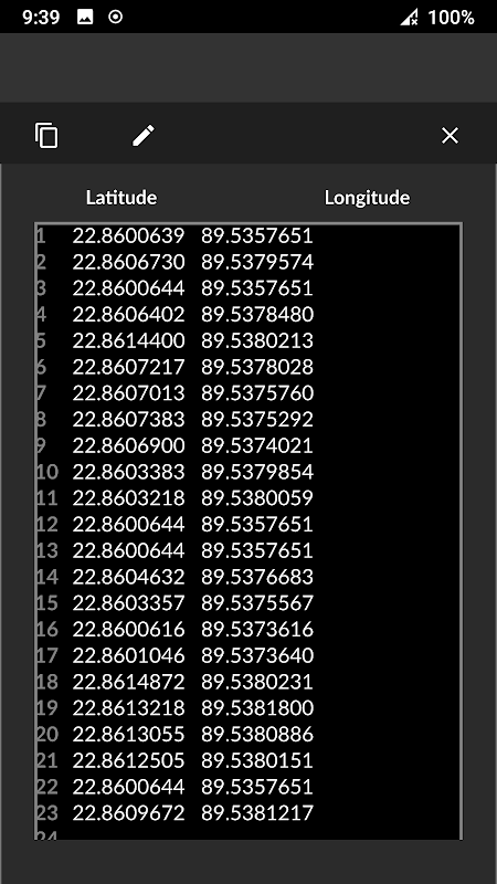
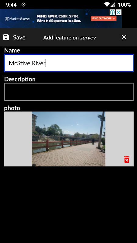
→ Collect unlimited points with "name" and "description". You can record your location or any place you want.
→ Add point with coordinates ( x, y or latitude, longitude).
→ Make surveying easy using QGIS projects.
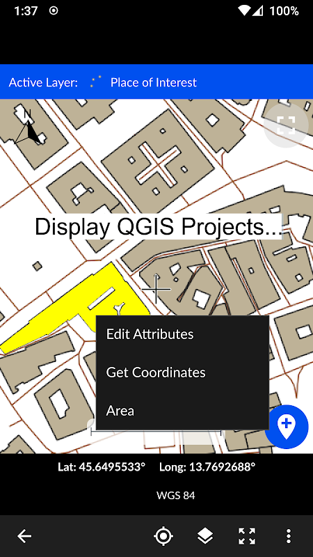
- Map Viewer: Displays QGIS 3 projects.
→ It is possible to include geospatial data to display maps on this app;
→ Raster (GeoTIFF, DEM, JPEG, PNG, GRD, XYZ, ..),
→ CAD (DXF, DGN v7),
→ GIS (ArcGIS shp, Google Earth (kml, kmz), GeoJSON, GPX..),
→ Online map services (Open Street Maps, Hybrid Maps, Satellite Maps, Terrain Maps..) Online maps can be prepared using QuickMapServices plugin in QGIS. You can add Open Street Maps, hybrid or satellite maps in QGIS project for Surveying Calculator.
→ Geodatabase (GeoPackage, Spatialite) formats in QGIS projects.
- Coordinate System support:
→ Supports 5000 different EPSG coordinate systems.
→ User can search a coordinate system with country name or coordinate system name on epsg.io site. And user can create jobs with a proper EPSG code.
→ The coordinate system can be projected ( in feet or meters units) or geographic (in degree)
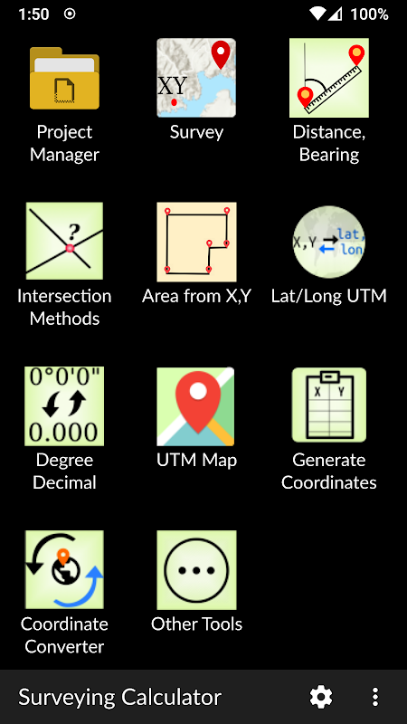
- Generate Coordinates: Generate coordinates in latitude/ longitude or in X, Y.
- Basic Surveying Tools: X(N), Y(E) Calculation, Distance, Azimuth Calculation, Interior Angle, Latitude Longitude from point, distance and bearing
- Intersection Methods: Forward Intersection, Line - Line Intersection, Circle by 3 Points
- Distance between Coordinates: 2D, 3D distance from X, Y and distance from Latitude, Longitude
- Area calculation from coordinates
- Degree - Decimal Conversion
- Coordinate Converter: WGS84 Latitude/Longitude to UTM XY or UTM XY to Latitude/Longitude Conventer, 2D Helmert transformation
- Settings: Coordinate order of northing, easting or latitude, longitude. DMS or decimal options for geographic coordinate systems. Scale bar unit settings in metric or imperial.
- and more.
Surveying Calculator supports Android 6.0 and up. Minimum 2GB RAM with 300MB free space are recommended.
Some of the new modules have bugs with the new update:
- Start Survey: The app sometimes closes unexpectedly when GPS button is active. To prevent this problem, turn off GPS mode before exiting Start Survey.
- Scale bar sometimes gives wrong results after adding layers and storing points.
- Projects sometimes display rotated map on Start Survey and Map View.
- Points are sometimes not recorded in Geopackage format.
It is planned to fix the weird bugs for next updates.
If you need help or if you have any suggestion about this app please mail to [email protected] or join Surveying Calculator Facebook group to ask questions. You can follow news about the app on Facebook Page:
fb.me/surveyingcalculator
เครื่องคิดเลขการสำรวจมีเครื่องมือสำรวจที่ดินที่ใช้กันทั่วไป ซึ่งรวมถึงการคำนวณพิกัดเชิงเรขาคณิตการรวบรวมข้อมูลจุดออฟไลน์การแสดง CAD, GIS, ข้อมูลแรสเตอร์และแผนที่ออนไลน์ในรูปแบบโครงการ QGIS 3 เครื่องคิดเลขการสำรวจสนับสนุนโครงการ QGIS 3 (qgs, qgz)
คุณสมบัติ :
- Jobs:
และ rarr; สร้างงานไม่ จำกัด สำหรับการรวบรวมคะแนนในรูปแบบ SHP หรือ GeoPackage ด้วยรหัสระบบพิกัด (รหัส EPSG)
และ rarr; คุณยังสามารถเตรียมงานใน QGIS บนเดสก์ท็อปด้วยข้อมูลเชิงพื้นที่ นำเข้า CAD, GIS, ข้อมูลแรสเตอร์หรือเพิ่มบริการแผนที่ออนไลน์ใน QGIS และถ่ายโอนโฟลเดอร์ข้อมูลไปยังโฟลเดอร์ Surveying_Calculator / projects บนอุปกรณ์ของคุณ เลือกโครงการในงานและเริ่มสำรวจ
- เริ่มการสำรวจ:
และ rarr; รวบรวมคะแนนไม่ จำกัด ด้วย "ชื่อ" และ "คำอธิบาย" คุณสามารถบันทึกตำแหน่งของคุณหรือสถานที่ที่คุณต้องการ
และ rarr; เพิ่มจุดที่มีพิกัด (x, y หรือละติจูด, ลองจิจูด)
และ rarr; ทำให้การสำรวจง่ายขึ้นโดยใช้โครงการ QGIS
- โปรแกรมดูแผนที่: แสดงโครงการ QGIS 3
และ rarr; เป็นไปได้ที่จะรวมข้อมูลเชิงพื้นที่เพื่อแสดงแผนที่ในแอพนี้
และ rarr; แรสเตอร์ (GeoTIFF, DEM, JPEG, PNG, GRD, XYZ, .. ),
และ rarr; CAD (DXF, DGN v7),
และ rarr; GIS (ArcGIS shp, Google Earth (kml, kmz), GeoJSON, GPX .. ),
และ rarr; บริการแผนที่ออนไลน์ (Open Street Maps, Hybrid Maps, แผนที่ดาวเทียม, Terrain Maps .. ) สามารถเตรียมแผนที่ออนไลน์โดยใช้ QuickMapServices plugin ใน QGIS คุณสามารถเพิ่มแผนที่ถนนเปิดไฮบริดหรือแผนที่ดาวเทียมในโครงการ QGIS สำหรับการสำรวจเครื่องคิดเลข
และ rarr; รูปแบบ Geodatabase (GeoPackage, Spatialite) ในโครงการ QGIS
- การสนับสนุนระบบพิกัด:
และ rarr; รองรับระบบพิกัด EPSG ที่แตกต่างกันถึง 5,000 ระบบ
และ rarr; ผู้ใช้สามารถค้นหาระบบพิกัดด้วยชื่อประเทศหรือชื่อระบบพิกัดบนไซต์ epsg.io และผู้ใช้สามารถสร้างงานด้วยรหัส EPSG ที่เหมาะสม
และ rarr; ระบบพิกัดสามารถฉายได้ (หน่วยเป็นฟุตหรือเมตร) หรือพื้นที่ทางภูมิศาสตร์ (เป็นหน่วยองศา)
- สร้างพิกัด: สร้างพิกัดในละติจูด / ลองจิจูดหรือใน X, Y
- เครื่องมือสำรวจพื้นฐาน: การคำนวณ X (N), Y (E), ระยะทาง, การคำนวณ Azimuth, มุมภายใน, ละติจูดลองจิจูดจากจุด, ระยะทางและการแบก
- วิธีการทางแยก: ทางแยกไปข้างหน้า, บรรทัด - ทางแยกบรรทัด, วงกลม 3 คะแนน
- ระยะห่างระหว่างพิกัด: 2D, 3D ระยะทางจาก X, Y และระยะทางจากละติจูดลองจิจูด
- การคำนวณพื้นที่จากพิกัด
- ดีกรี - การแปลงทศนิยม
- ตัวแปลงพิกัด: ละติจูด / ลองจิจูดเป็น UTM XY หรือ UTM XY เป็นละติจูด / ลองจิจูด Conventer, การแปลง 2D Helmert
- การตั้งค่า : ลำดับการประสานของทิศเหนือทิศตะวันออกหรือละติจูดลองจิจูด DMS หรือตัวเลือกทศนิยมสำหรับระบบพิกัดทางภูมิศาสตร์ ปรับการตั้งค่าหน่วยแท่งเป็นเมตริกหรืออิมพีเรียล
- และอื่น ๆ
เครื่องคำนวณแบบสำรวจรองรับ Android 6.0 ขึ้นไป แนะนำให้ใช้ 2GB RAM ขั้นต่ำพร้อมพื้นที่ว่าง 300MB
โมดูลใหม่บางส่วนมีข้อบกพร่องพร้อมการอัปเดตใหม่:
- เริ่มสำรวจ: บางครั้งแอพจะปิดโดยไม่คาดคิดเมื่อปุ่ม GPS เปิดใช้งาน เพื่อป้องกันปัญหานี้ให้ปิดโหมด GPS ก่อนออกจาก Start Survey
- สเกลบาร์บางครั้งให้ผลลัพธ์ที่ผิดหลังจากเพิ่มเลเยอร์และเก็บคะแนน
- บางครั้งโครงการจะแสดงแผนที่หมุนในการเริ่มการสำรวจและมุมมองแผนที่
- บางครั้งคะแนนไม่ถูกบันทึกในรูปแบบ Geopackage
มีการวางแผนที่จะแก้ไขข้อผิดพลาดที่แปลกสำหรับการปรับปรุงต่อไป
หากคุณต้องการความช่วยเหลือหรือมีข้อเสนอแนะใด ๆ เกี่ยวกับแอพนี้กรุณาส่งอีเมลไปที่ [email protected] หรือเข้าร่วมกลุ่มสำรวจเครื่องคิดเลข Facebook เพื่อถามคำถาม คุณสามารถติดตามข่าวสารเกี่ยวกับแอพได้ในหน้า Facebook:
fb.me/surveyingcalculator
What's New
- Added Jobs, Start Survey, Map View and Coordinate Generator modules.
- Able to add jobs in SHP or GeoPackage formats
- Able to store unlimited points in SHP or GeoPackage formats. Almost all coordinate systems supported in the world (5000+ EPSG coordinate systems support)
- Support for displaying the formats: Rasters (GeoTIFF, DEM, JPEG, E00, GRD...), CAD (DXF, DGN), GIS (SHP, KML, KMZ, GML, GPX, GeoJSON...), and Geospatial database (GeoPackage, Spatialite)
- Updated Settings
Latest Version (Download)
Surveying Calculator 3.5.4Date Updated : 2023-01-17
Advertisement
