Advertisement
Latest Version (Download)Table of Contents
Advertisement
Information
| Package | com.peaklens.ar |
| Version | 1.1.17 |
| Date Updated | 2021-12-29 |
| Size | 34.35 MB |
| Installs | 860 |
| Categories | , |
Screenshots


Description
App เติมความเป็นจริงสำหรับการรับรู้ยอดเขาได้อย่างแม่นยำออนไลน์และออฟไลน์
PeakLens will transform your mountain activity into an amazing experience, allowing you to get a deeper knowledge of the mountains and to create stunning photos enriched with the most accurate information about the peaks in view.
Discover the names and locations of mountain and hills around you while hiking, climbing, skiing, trekking or enjoying your favorite outdoor activity. Test your mountain knowledge and share your pictures of stunning skyline views with your friends on social networks.
FEATURES
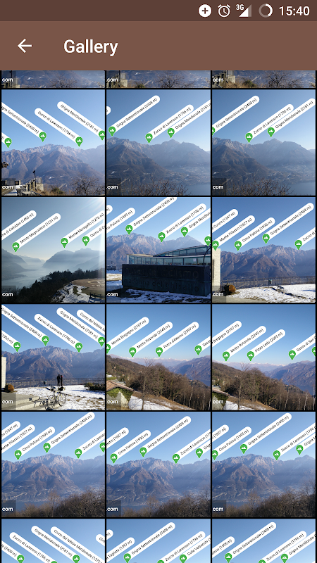
- Precisely identifies mountain peaks and hills in real-time.
- Works worldwide: from Alps, Himalayas, Rocky Mountains and Andes up to the smallest hills, anywhere on Earth.
- Corrects GPS, compass, magnetometer and gyroscope errors with artificial intelligence.
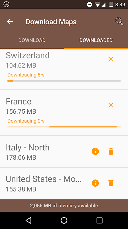
- Works online and offline with pre-downloaded maps.
- High quality photographs with peak names in overlay.
- Knows position, height and distance from you of more than 200.000 peaks.
- Works both with Imperial and Metric unit systems.
PeakLens is a novel Augmented Reality and Virtual Reality app for mountain lovers, hikers and trekkers. It is the result of years of research in artificial intelligence and computer vision, based on a novel algorithm that identifies mountain peaks in real time with high precision. Its core is a software component that compares what you actually see in the camera of your mobile phone or tablet with a virtual panorama, created from a digital 3D landscape model of the Earth. By matching what you see and the virtual panorama, PeakLens automatically corrects most errors that come from the imprecision of the compass and GPS sensor, giving you always the most accurate peak positioning.
RESOURCES
- Digital Elevation Model: the digital elevation model of the SRTM project (https://www2.jpl.nasa.gov/srtm) is used for calculating panoramic views.
- Peaks: the Peaks dataset is extracted from Openstreetmap.com.
OpenStreetMap is open data, licensed under the Open Data Commons Open Database License (ODbL).
PeakLens is a research result of Politecnico di Milano, Dipartimento di Elettronica, Informatica e Bioingegneria.
For any comments, questions or feedbacks contact us at [email protected]!
PeakLens จะเปลี่ยนกิจกรรมภูเขาของคุณเป็นประสบการณ์ที่น่าตื่นตาตื่นใจที่ช่วยให้คุณได้รับความรู้ลึกของภูเขาและการสร้างภาพที่สวยงามอุดมไปด้วยข้อมูลที่ถูกต้องที่สุดเกี่ยวกับยอดเขาในมุมมอง
ค้นพบชื่อและสถานที่ตั้งของภูเขาและเนินเขารอบ ๆ ตัวคุณในขณะที่การเดินป่า, ปีนเขา, สกี, เดินป่าหรือเพลิดเพลินกับกิจกรรมกลางแจ้งที่คุณชื่นชอบ ทดสอบความรู้ของภูเขาของคุณและแบ่งปันภาพถ่ายของคุณการดูเส้นขอบฟ้าที่สวยงามกับเพื่อนของคุณบนเครือข่ายสังคม
คุณสมบัติ
- แม่นยำระบุยอดภูเขาและเนินเขาในเวลาจริง
- ทำงานทั่วโลก: จากเทือกเขาแอลป์เทือกเขาหิมาลัยเทือกเขาร็อคกี้และแอนดีสถึงเนินเขาเล็กที่สุดที่ใดก็ได้ในโลก
- แก้ไข GPS, เข็มทิศ, magnetometer และหมุนข้อผิดพลาดกับปัญญาประดิษฐ์
- ทำงานออนไลน์และออฟไลน์ที่มีแผนที่ก่อนดาวน์โหลด
- ภาพที่มีคุณภาพสูงที่มีชื่อสูงสุดในการซ้อนทับ
- รู้ตำแหน่งสูงและระยะทางจากคุณมากกว่า 200.000 ยอด
- ทำงานร่วมกับระบบทั้งหน่วยอิมพีเรียลและเมตริก
PeakLens เป็นนวนิยาย Augmented Reality และ app เสมือนจริงสำหรับคนรักภูเขา, นักเดินทางไกลและนักเดินป่า มันเป็นผลมาจากการปีของการวิจัยในด้านปัญญาประดิษฐ์และวิสัยทัศน์คอมพิวเตอร์ขึ้นอยู่กับขั้นตอนวิธีการนวนิยายที่ระบุยอดภูเขาในเวลาจริงที่มีความแม่นยำสูง หลักของมันคือคอมโพเนนต์ซอฟต์แวร์ที่เปรียบเทียบสิ่งที่คุณเห็นจริงในกล้องของโทรศัพท์มือถือหรือแท็บเล็ตที่มีภาพพาโนรามาเสมือนสร้างขึ้นจากรูปแบบภูมิทัศน์ 3 มิติดิจิตอลของโลก โดยการจับคู่สิ่งที่คุณเห็นและพาโนรามาเสมือน PeakLens จะแก้ไขข้อผิดพลาดมากที่สุดที่มาจากความไม่แน่ชัดของเข็มทิศและ GPS เซ็นเซอร์ให้คุณเสมอตำแหน่งสูงสุดที่ถูกต้องที่สุด
ทรัพยากร
- ดิจิตอลสูงแบบ: รูปแบบดิจิตอลระดับความสูงของโครงการ SRTM นี้ (https://www2.jpl.nasa.gov/srtm) จะใช้สำหรับการคำนวณทัศนียภาพอันงดงาม
- Peaks: ชุดข้อมูล Peaks สกัดจาก Openstreetmap.com
OpenStreetMap เป็นข้อมูลที่เปิดรับใบอนุญาตภายใต้การเปิดข้อมูล Commons Open License ฐานข้อมูล (ODbL)
PeakLens เป็นผลงานวิจัยของ Politecnico di Milano, Dipartimento di Elettronica, Informatica อี Bioingegneria
สำหรับความคิดเห็นใด ๆ คำถามหรือการตอบติดต่อเราได้ที่ [email protected]!
What's New
This version includes some minor bug fixes and x86_64 architecture support
Latest Version (Download)
PeakLens 1.1.17Date Updated : 2021-12-29
Advertisement
