Advertisement
Latest Version (Download)Table of Contents
Advertisement
Information
| Package | net.osmand.plus |
| Version | 3.4.8 |
| Date Updated | 2021-02-12 |
| Size | 72.61 MB |
| Installs | 184.2K+ |
| Categories | แอปพลิเคชั่น, ท่องเที่ยว |
Screenshots


Description
เดินทางแผนที่แบบออฟไลน์จุดที่น่าสนใจการเดินทางและระบบนำร่องตามข้อมูล OpenStreetMap (OSM)
OsmAnd+ (OSM Automated Navigation Directions) is a map and navigation application with access to the free, worldwide, and high-quality OpenStreetMap (OSM) data.
Enjoy voice and optical navigation, viewing POIs (points of interest), creating and managing GPX tracks, using contour lines visualization and altitude info, a choice between driving, cycling, pedestrian modes, OSM editing and much more.
OsmAnd+ is the paid application version. By buying it, you support the project, fund the development of new features, and receive the latest updates.
Some of the main features:
Navigation
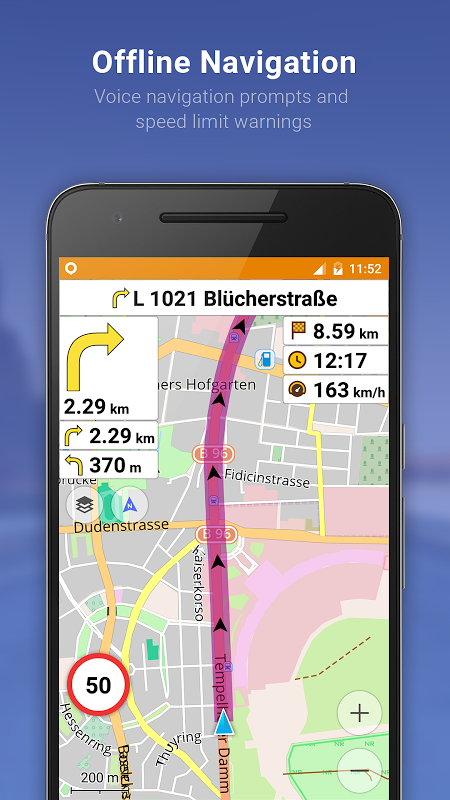
• Works online (fast) or offline (no roaming charges when you are abroad)
• Turn-by-turn voice guidance (recorded and synthesized voices)
• Optional lane guidance, street name display, and estimated time of arrival
• Supports intermediate points on your itinerary
• Automatic re-routing whenever you deviate from the route
• Search for places by address, by type (e.g.: restaurant, hotel, gas station, museum), or by geographical coordinates
• OSM Public Transport
Map Viewing
• Display your position and orientation
• Optionally align the picture according to compass or your direction of motion
• Save your most important places as Favorites
• Display POIs (point of interests) around you
• Display specialized online tiles, satellite view (from Bing), different overlays like touring/navigation GPX tracks and additional layers with customizable transparency
• Optionally display place names in English, local, or phonetic spelling
Use OSM and Wikipedia Data
• High-quality information from the best collaborative projects of the world
• OSM data available per country or region
• Wikipedia POIs, great for sightseeing
• Unlimited free downloads, directly from the app
• Compact offline vector maps updated at least once a month
• Selection between complete region data and just road network (Example: All of Japan is 700 MB or 200 MB for the road network only)
Safety Features
• Optional automated day/night view switching
• Optional speed limit display, with reminder if you exceed it
• Optional speed-dependent zooming
• Share your location so that your friends can find you
Bicycle and Pedestrian Features
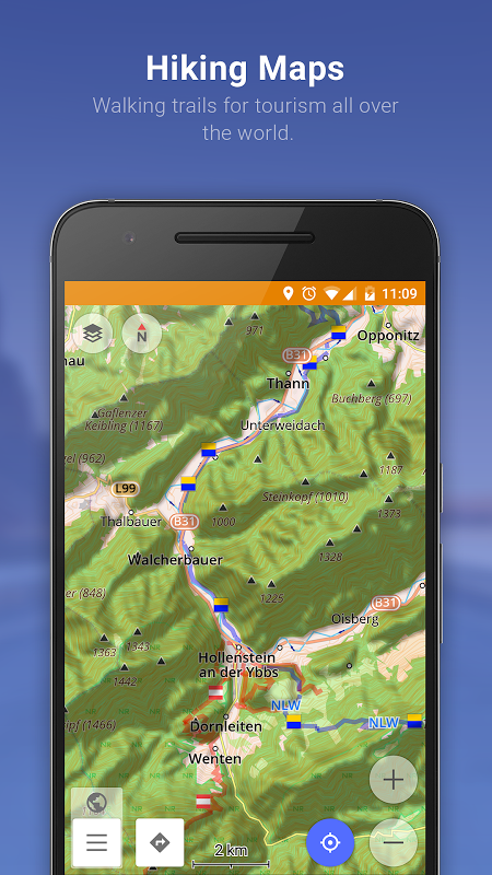
• Viewing foot, hiking, and bike paths, great for outdoor activities
• Special routing and display modes for bike and pedestrian
• Optional public transport stops (bus, tram, train) including line names
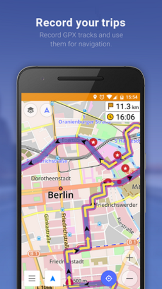
• Optional trip recording to local GPX file or online service
• Optional speed and altitude display
• Display of contour lines and hill-shading (via additional plugin)
Public transport
• Navigation on public transport: Metro, Buses, Tram and so on.
Directly Contribute to OSM
• Report data bugs
• Upload GPX tracks to OSM directly from the app
• Add POIs and directly upload them to OSM (or later if offline)
• Optional trip recording also in background mode (while device is in sleep mode)
OsmAnd is open-source and actively being developed. Everyone can contribute to the application by reporting bugs, improving translations or coding new features. The project is in a lively state of continuous improvement by all these forms of developer and user interaction. The project progress also relies on financial contributions to fund coding and testing of new functionalities.
Approximate map coverage and quality:
• Western Europe: ****
• Eastern Europe: ***
• Russia: ***
• North America: ***
• South America: **
• Asia: **
• Japan & Korea: ***
• Middle East: **
• Africa: **
• Antarctica: *
Most countries around the globe available as downloads!
From Afghanistan to Zimbabwe, from Australia to the USA. Argentina, Brazil, Canada, France, Germany, Mexico, UK, Spain, ...
Important! Older versions of OsmAnd: 2.1.2 and 1.9.7 use the device administrator's permission for the “Enable Screen” feature. The resolution allows OsmAnd to turn on the screen before turning during navigation.
OsmAnd + (OSM Automated Navigation Directions) เป็นแอปพลิเคชั่นแผนที่และการนำทางพร้อมการเข้าถึงข้อมูล OpenStreetMap (OSM) ฟรีทั่วโลกและคุณภาพสูง
เพลิดเพลินกับการนำทางด้วยเสียงและออพติคอลการดู POI (จุดที่น่าสนใจ) การสร้างและจัดการแทร็ก GPX โดยใช้การแสดงภาพเส้นชั้นความสูงและข้อมูลระดับความสูงทางเลือกระหว่างการขับขี่ขี่จักรยานโหมดคนเดินเท้า
OsmAnd + เป็นรุ่นแอปพลิเคชันที่ต้องชำระเงิน โดยการซื้อคุณสนับสนุนโครงการกองทุนการพัฒนาคุณสมบัติใหม่และรับการปรับปรุงล่าสุด
คุณสมบัติหลักบางประการ:
การเดินเรือ
•ใช้งานออนไลน์ (เร็ว) หรือออฟไลน์ (ไม่มีค่าบริการโรมมิ่งเมื่อคุณอยู่ต่างประเทศ)
•คำแนะนำด้วยเสียงแบบเลี้ยวต่อเลี้ยว (บันทึกและสังเคราะห์เสียง)
•คำแนะนำช่องทางเลือกการแสดงชื่อถนนและเวลาที่คาดว่าจะมาถึง
•รองรับคะแนนกลางในการเดินทางของคุณ
•เปลี่ยนเส้นทางอัตโนมัติเมื่อใดก็ตามที่คุณเบี่ยงเบนจากเส้นทาง
•ค้นหาสถานที่ตามที่อยู่ตามประเภท (เช่นร้านอาหารโรงแรมสถานีบริการน้ำมันพิพิธภัณฑ์) หรือตามพิกัดทางภูมิศาสตร์
•ระบบขนส่งสาธารณะ OSM
การดูแผนที่
•แสดงตำแหน่งและทิศทางของคุณ
•จัดแนวรูปภาพตามเข็มทิศหรือทิศทางการเคลื่อนไหวของคุณ
•บันทึกสถานที่ที่สำคัญที่สุดของคุณเป็นรายการโปรด
•แสดง POI (จุดสนใจ) รอบตัวคุณ
•แสดงไทล์ออนไลน์แบบพิเศษมุมมองดาวเทียม (จาก Bing) ภาพซ้อนทับที่แตกต่างกันเช่นการเดินทาง / การนำทางแทร็ก GPX และเลเยอร์เพิ่มเติมด้วยความโปร่งใสที่ปรับแต่งได้
•เลือกแสดงชื่อของสถานที่ในการสะกดคำภาษาอังกฤษท้องถิ่นหรือการออกเสียง
ใช้ OSM และข้อมูล Wikipedia
•ข้อมูลคุณภาพสูงจากโครงการความร่วมมือที่ดีที่สุดของโลก
•มีข้อมูล OSM ต่อประเทศหรือภูมิภาค
• Wikipedia POI เหมาะสำหรับการเที่ยวชม
•ดาวน์โหลดฟรีไม่ จำกัด โดยตรงจากแอพ
•แผนที่เวกเตอร์ออฟไลน์ขนาดกะทัดรัดที่อัปเดตอย่างน้อยเดือนละครั้ง
•การเลือกระหว่างข้อมูลภูมิภาคที่สมบูรณ์และเครือข่ายถนน (ตัวอย่าง: ญี่ปุ่นทั้งหมด 700 MB หรือ 200 MB สำหรับเครือข่ายถนนเท่านั้น)
คุณลักษณะด้านความปลอดภัย
•ตัวเลือกสลับมุมมองกลางวัน / กลางคืนอัตโนมัติ
•จอแสดงผล จำกัด ความเร็วที่เป็นตัวเลือกพร้อมเตือนถ้าคุณเกินมัน
•ตัวเลือกการซูมขึ้นกับความเร็ว
•แชร์ตำแหน่งของคุณเพื่อให้เพื่อน ๆ หาคุณเจอ
คุณสมบัติของจักรยานและคนเดินเท้า
•ดูเท้าเดินป่าและเส้นทางจักรยานเหมาะสำหรับกิจกรรมกลางแจ้ง
•โหมดเส้นทางและจอแสดงผลพิเศษสำหรับจักรยานและคนเดินเท้า
•ระบบขนส่งสาธารณะที่เป็นตัวเลือกหยุด (รถบัสรถรางรถไฟ) รวมถึงชื่อสาย
•ตัวเลือกบันทึกการเดินทางไปยังไฟล์ GPX ในพื้นที่หรือบริการออนไลน์
•แสดงความเร็วและความสูงได้
•การแสดงเส้นชั้นความสูงและการบังเงา (ผ่านปลั๊กอินเสริม)
การขนส่งสาธารณะ
•การนำทางในการขนส่งสาธารณะ: รถไฟใต้ดินรถบัสรถรางและอื่น ๆ
มีส่วนร่วมโดยตรงกับ OSM
•รายงานข้อบกพร่องของข้อมูล
•อัปโหลดแทร็ก GPX ไปที่ OSM โดยตรงจากแอป
•เพิ่ม POI และอัพโหลดไปยัง OSM โดยตรง (หรือใหม่กว่าถ้าออฟไลน์)
•บันทึกการเดินทางเสริมในโหมดพื้นหลัง (ในขณะที่อุปกรณ์อยู่ในโหมดสลีป)
OsmAnd เป็นโอเพ่นซอร์สและกำลังพัฒนาอย่างแข็งขัน ทุกคนสามารถมีส่วนร่วมในแอปพลิเคชันโดยการรายงานข้อบกพร่องปรับปรุงการแปลหรือการเข้ารหัสคุณสมบัติใหม่ โครงการอยู่ในสภาพที่มีชีวิตชีวาของการปรับปรุงอย่างต่อเนื่องโดยนักพัฒนาและการโต้ตอบกับผู้ใช้ทุกรูปแบบ ความคืบหน้าของโครงการขึ้นอยู่กับการมีส่วนร่วมทางการเงินในการเขียนโปรแกรมและทดสอบฟังก์ชั่นใหม่ ๆ
ความครอบคลุมและคุณภาพของแผนที่โดยประมาณ:
• ยุโรปตะวันตก: ****
• ยุโรปตะวันออก: ***
•รัสเซีย: ***
• อเมริกาเหนือ: ***
• อเมริกาใต้: **
•เอเชีย: **
•ญี่ปุ่นและเกาหลี: ***
• ตะวันออกกลาง: **
•แอฟริกา: **
•แอนตาร์กติกา: *
ประเทศส่วนใหญ่ทั่วโลกสามารถดาวน์โหลดได้!
จากอัฟกานิสถานถึงซิมบับเวจากออสเตรเลียถึงสหรัฐอเมริกา อาร์เจนตินา, บราซิล, แคนาดา, ฝรั่งเศส, เยอรมันนี, เม็กซิโก, อังกฤษ, สเปน, ...
สำคัญ! OsmAnd เวอร์ชั่นเก่ากว่า: 2.1.2 และ 1.9.7 ใช้สิทธิ์ของผู้ดูแลระบบอุปกรณ์สำหรับคุณสมบัติ“ เปิดใช้งานหน้าจอ” ความละเอียดช่วยให้ OsmAnd เปิดหน้าจอก่อนที่จะเปิดระหว่างการนำทาง
What's New
• New Directions screen: Displays Home and Work destination buttons, previous route shortcut, list of active tracks, search history
• Additional info under 'Route details': road types, surface, steepness, smoothness
• Public transport navigation
• New Quick action for show/hide tracks and day/night modes
• Fixed flooded areas in Germany, South Africa, Quebec
• Improved import for KML and KMZ import
• Fixed crashes on opening some public transport stops
Latest Version (Download)
OsmAnd+ — Offline Travel Maps & Navigation 3.4.8Date Updated : 2021-02-12
Advertisement
