Advertisement
Latest Version (Download)Table of Contents
Advertisement
Information
| Package | menion.android.locus.pro |
| Version | 3.48.2 |
| Date Updated | 2021-01-21 |
| Size | 41.16 MB |
| Installs | 106.4K+ |
| Categories | , |
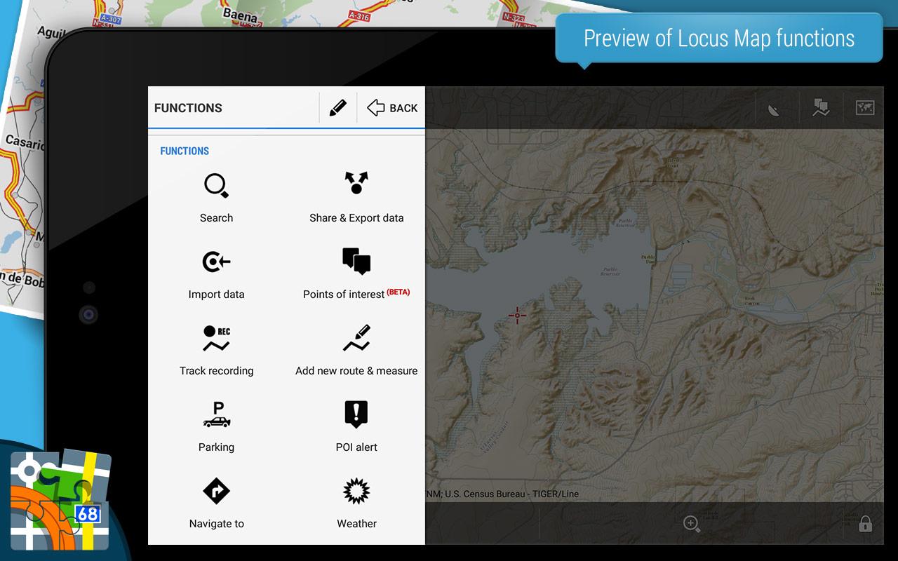
Screenshots


Description
โปรแกรมนำทางอเนกประสงค์สำหรับผู้เชี่ยวชาญกลางแจ้งและมืออาชีพ
An ultimate navigation application for all outdoor enthusiasts - hikers, mountainbikers, mountaineers, trail runners or geocachers. And not only for them, Locus Map Pro is widely used also by professionals - explorers, travelers or rescue squads all over the world.
Locus Map Pro offers true multi functionality and flexibility:
• advanced navigation capability, supporting online and offline routing services
• unprecedented choice of premium online and offline maps
• advanced map tools - map overlays, offsets, WMS sources support
• tools for monitoring sports activities - track recording, customizable dashboard, audio coach, charts, statistics, support of external BL/ANT+ sensors (GPS, HRM, cadence...)
• worldwide weather 24/7 forecast
• sophisticated tools for geocaching - location tools, online/offline logging, support of trackables, Pocket Queries, spoilers...
Map portfolio:
•LoMaps - offline maps of all the World - containing hiking/biking map, winter map, road map or city plan themes. FREE DOWNLOAD of the first 3 LoMaps.
Detailed hiking maps and cycling maps of the best world map publishers:
•Great Britain by Ordnance Survey (Explorer, Landranger),
•USA by USGS classic/satellite, NeoTreks (AccuTerra),
•Canada by BackRoad Map Books,
•maps of Switzerland by SwissTopo, Belgium by IGN Belgium, France by IGN France, Denmark by Kortforsyningen, Iceland by LMI Atlas Map, Netherlands by Map5.nl, Slovenia by PZS Maps, Spain by CNIG maps, Sweden by Lantmäteriet, Poland by Compass, Germany, Austria and North Italy by Kompass, Outdooractive – Summer and Winter maps, Basemap.at and Freytag-Berndt, Czechia and Slovakia by SHOCart and Geodézie Online
and many others...
•support of external maps in MAP, SQLite, TAR, MBT, GEMF, Orux or RMA formats, and of own OpenStreetMap or map themes
Features:
Navigation and guidance
• turn•by•turn voice navigation with support of online/offline routing services
• beeline guidance to a point (on map or by compass) or along a route with notifications
Tracks&Routes
• multi•profile track recording
• charts&statistics
• audio coach - commented workouts
• support of Bluetooth/ANT+ external sensors - HRM, speed/cadence, GPS, NMEA
• route planning
• import/export of routes/tracks from/to various formats (KML, KMZ, GPX...) and web services (Strava, Runkeeper, GPSies, Google Earth, Freelogbook.biz etc...)
• customizable bike computer dashboard
Points
• creating own database - order, search, sort
• import/export in many formats, web services support
• OSM POIs
Map tools
• map overlay, calibration and offsets
• support of various external map formats and coordinate systems
• visualising geotagged photos, OSM notes
Search
• online and offline addresses
• OSM POIs, GeoNames and Wikipedia
Geocaching
• downloading geocaches via Geocaching4Locus add•on
• offline and online logging
• support of waypoints, PocketQuery, trackables, spoilers
• graphic and calculation tools
Live tracking
• private or public sharing of location in real time
And much more
• parking assistant, sunrise/sunset time, world wide weather forecast, NFC tagger, QR code generator...
This app uses the Device Administrator permission.
Locus Map Pro is highly customizable. Everything can be set according to user's needs. Its functionality can be further extended by numerous Add•ons - Locus Map Watch, Augmented reality, GeoGet/GSAK, Pebble, Munzee etc.
Homepage:
http://www.locusmap.eu
Help desk:
http://help.locusmap.eu
Manual:
http://docs.locusmap.eu/
แอปพลิเคชันการนำทางที่ดีที่สุดสำหรับผู้ที่ชอบเล่นกลางแจ้งทั้งหมด - นักปีนเขานักปีนภูเขานักปีนเขานักวิ่งทางแนวเส้นทางหรือนัก ธ รุผู้ Locus Map Pro มีการใช้กันอย่างกว้างขวางทั้งในหมู่นักสำรวจนักเดินทางหรือทีมกู้ภัยทั่วโลก
Locus Map Pro มีฟังก์ชันและความยืดหยุ่นที่หลากหลาย:
•ความสามารถขั้นสูง navigation ซึ่งสนับสนุนบริการเส้นทางออนไลน์และออฟไลน์
•การเลือกแผนที่ออนไลน์และออฟไลน์พรีเมียมแบบไม่เสียค่าใช้จ่าย b>• เครื่องมือแผนที่ขั้นสูง - การซ้อนทับแผนที่การชดเชยการสนับสนุนแหล่ง WMS
เครื่องมือสำหรับการตรวจสอบกิจกรรมกีฬา - การติดตามบันทึกแดชบอร์ดที่ปรับแต่งได้, เสียงโค้ช, แผนภูมิสถิติการสนับสนุน BL / ANT + เซ็นเซอร์ภายนอก (GPS, HRM, จังหวะ ... )
•ทั่วโลก พยากรณ์อากาศ 24/7 / b>•เครื่องมือที่ซับซ้อนสำหรับ geocaching - เครื่องมือตำแหน่งการบันทึกข้อมูลออนไลน์ / ออฟไลน์การสนับสนุน trackables การค้นหาพ็อกเก็ตสปอยเลอร์ ...
พอร์ตโฟลิโอของแผนที่:
• LoMaps - แผนที่แบบออฟไลน์ของ World ทั้งหมด - ประกอบด้วยแผนที่เดินป่า / ขี่จักรยานแผนที่ฤดูหนาวแผนที่ถนนหรือแผนผังเมือง ดาวน์โหลดฟรี 3 LoMaps แรก
รายละเอียด แผนที่เดินป่าและแผนที่ขี่จักรยาน ของผู้เผยแพร่แผนที่โลกที่ดีที่สุด:
• สหราชอาณาจักร โดย Ordnance Survey (Explorer, Landranger),
สหรัฐอเมริกา โดย USGS classic / satellite, NeoTreks (AccuTerra),
• แคนาดา โดย BackRoad Map Books,
แผนที่ของ Switzerland โดย SwissTopo, Belgium โดย IGN Belgium, ฝรั่งเศส โดย IGN France, Denmark โดย Kortforsyningen < ประเทศเนเธอร์แลนด์ โดยแผนที่ Pnb, สโลวีเนีย โดยแผนที่ PZS, สเปน โดย CNIG maps < B> ประเทศโปแลนด์ โดยLantmäteriet, โปแลนด์ โดย Compass, เยอรมนีออสเตรียและเหนือ โดย Kompass, Outdooractive - แผนที่ฤดูร้อนและฤดูหนาว Basemap.at และ Freytag- Berndt, Czechia และ Slovakia โดย SHOCart และGeodézie Online
และอื่น ๆ อีกมากมาย...
การสนับสนุนแผนที่ภายนอก ในแผนที่, SQLite, TAR, MBT, GEMF, Orux หรือ RMA formats และ OpenStreetMap หรือแผนที่ของตัวเอง
คุณสมบัติ:
การนำทางและคำแนะนำ
•เปิด•โดย•เปิดการนำทางด้วยเสียงพร้อมการสนับสนุนบริการเส้นทางออนไลน์ / ออฟไลน์
•นำทางเส้นตรงไปยังจุด (บนแผนที่หรือด้วยเข็มทิศ) หรือตามเส้นทางที่มีการแจ้งเตือน
เพลงและเส้นทาง
•การบันทึกแทร็คแบบหลาย•
•แผนภูมิและสถิติ
•โค้ชเสียง - แสดงความคิดเห็นการออกกำลังกาย
•การสนับสนุน Bluetooth / ANT + เซนเซอร์ภายนอก - HRM, ความเร็ว / จังหวะ, GPS, NMEA
•การวางแผนเส้นทาง
•การนำเข้า / ส่งออกเส้นทาง / แทร็กจาก / ไปยังรูปแบบต่างๆ (KML, KMZ, GPX ... ) และบริการทางเว็บ (Strava, ผู้ครองเมือง, GPSies, Google Earth, Freelogbook.biz ฯลฯ .. )
•แดชบอร์ดคอมพิวเตอร์จักรยานที่ปรับแต่งได้
จุด
•การสร้างฐานข้อมูลของตัวเอง - เรียงลำดับการค้นหาเรียงลำดับ
•นำเข้า / ส่งออกในหลายรูปแบบการสนับสนุนบริการทางเว็บ
• OSI POIs
เครื่องมือแผนที่
•ซ้อนทับแผนที่การปรับเทียบและชดเชย
•การสนับสนุนรูปแบบแผนที่ภายนอกต่างๆและระบบพิกัด
•การแสดงผลภาพที่ติดแท็กภูมิศาสตร์, บันทึก OSM
การค้นหา
•ที่อยู่ออนไลน์และออฟไลน์
• OSI POIs, GeoNames และ Wikipedia
Geocaching
•ดาวน์โหลด geocaches ผ่านทาง Geocaching4Locus add • on
•ออฟไลน์และออนไลน์เข้าสู่ระบบ
•สนับสนุน waypoints, PocketQuery, trackables, spoilers
•เครื่องมือกราฟิกและการคำนวณ
การติดตามผลสด
•การแชร์ตำแหน่งส่วนตัวหรือสาธารณะในแบบเรียลไทม์
และอีกมากมาย
•ผู้ช่วยที่จอดรถเวลาพระอาทิตย์ขึ้น / พระอาทิตย์ตกการพยากรณ์อากาศทั่วโลก NFC tagger เครื่องกำเนิด QR code ...
แอปนี้ใช้สิทธิ์ผู้ดูแลระบบอุปกรณ์
Locus แผนที่ Pro สามารถปรับแต่งได้สูง ทุกอย่างสามารถตั้งค่าได้ตามความต้องการของผู้ใช้ การทำงานของมันสามารถขยายเพิ่มเติมได้โดย Add - ons - Locus Map Watch, ความเป็นจริงที่เพิ่มขึ้น, GeoGet / GSAK, Pebble, Munzee ฯลฯ
โฮมเพจ:
http://www.locusmap.eu
ฝ่ายช่วยเหลือ:
http://help.locusmap.eu
คู่มือ:
http://docs.locusmap.eu/
What's New
*** 3.37.2 ***
add: import and export of Garmin FIT files
add: brand new Live-tracking web site: https://live-tracking.locusmap.app
add: horizontal filter of GPS location
add: interpolation of manual segments in route planner (effect: correctly applied line style in segments + correct elevation chart after saving the route)
and many more...
Latest Version (Download)
Locus Map Pro - Outdoor GPS navigation and maps 3.48.2Date Updated : 2021-01-21
Advertisement
