Advertisement
Latest Version (Download)Table of Contents
Advertisement
Information
| Package | com.huntstand.core |
| Version | 5.5 |
| Date Updated | 2021-02-12 |
| Size | 8.71 MB |
| Installs | 1K+ |
| Categories | แอปพลิเคชั่น, กีฬา |
Screenshots
Description
HuntStand, # 1 App ฟรีล่าสัตว์ในโลก การทำแผนที่อากาศ, ลูกเสือ
HuntStand, the #1 free hunting app in the world, is the only hunting and land management app you will ever need. This revolutionary app is packed with invaluable mapping, weather, tracking, and social features.
HuntStand was carefully designed to work in both online and offline environments. Using this app, you will have access to offline weather and maps of your hunt areas. You can edit your maps while out “in the field” then sync them with your HuntStand account.
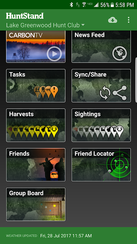
Use our Harvest, Sightings, and Task logging features to understand your property like never before.
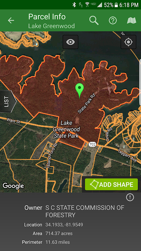
Access free property owner information and parcel boundary information for most of the country.
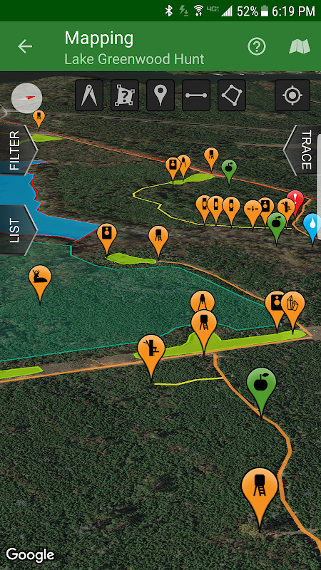
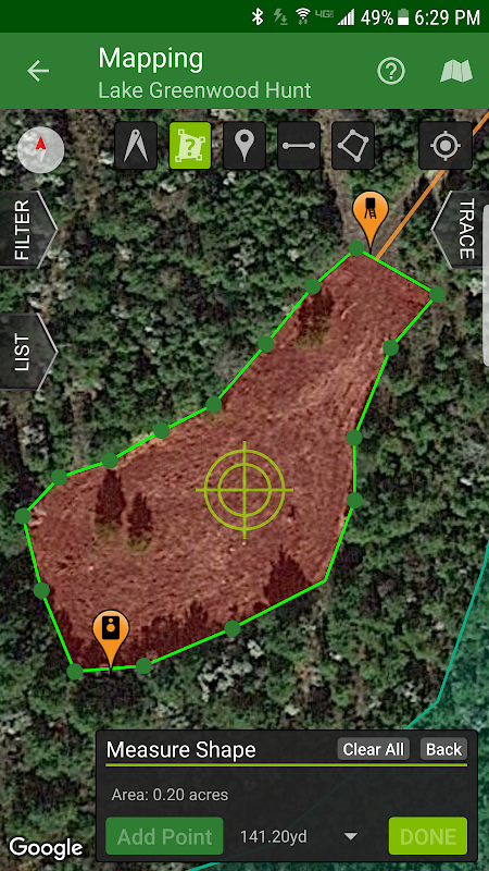
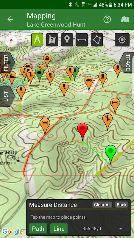
Fully map your property using 67 easily discernible custom icons, shapes, and lines including scouting marks, stands, property boundaries, food plots, ponds, roads, trails, and numerous other important objects of interest. Attach notes to your map objects and sort them by time and type.
View distance and area measurements using our advanced measurement tools. Our app will give you extremely accurate map-based distances in feet, meters, and yards and area measurements in acres.
HuntStand's interface is simple, yet powerful, and puts many useful tools right at your fingertips.
Create an account and gain the ability to:
-Sync Hunting Area maps with HuntStand.com
-View and edit maps using ultra-advanced on-line mapping features
-Share maps with friends
-Create a personal profile
-Join group hunting areas (allowing you to share and edit maps with your hunting friends)
-View advanced statistics built from your personal harvest and sighting history
-Sync your maps with other devices (Computers, tablets, phones, including both Android and iOS)
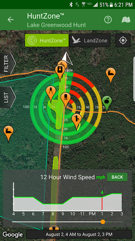
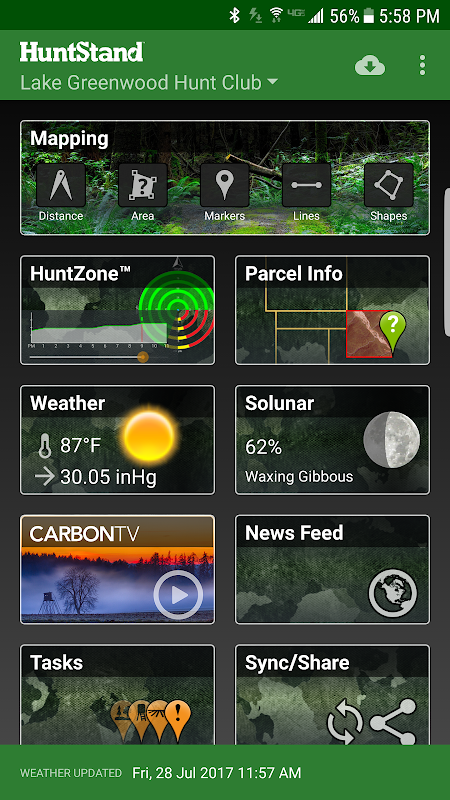
HuntStand features our revolutionary patent pending HuntZone technology. The HuntZone scent tool shows wind speed, direction, distance, and time in the most streamlined and efficient way possible. You can “slide” through wind forecasts and view the effects on your desired hunting area. The HuntZone tracks where your scent will be both at a specific time and throughout your hunt, allowing you to plan accordingly.
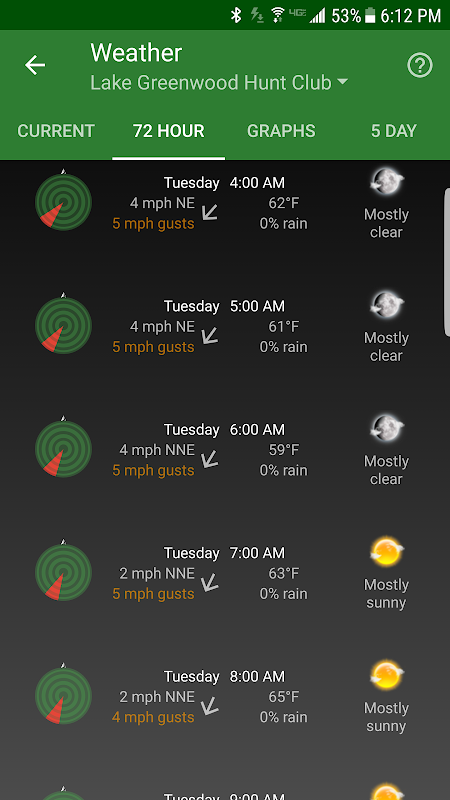
Have access to highly detailed weather and solunar information including a current weather page, (with useful charts) a 72 hour forecast, and a 5 day outlook.
HuntStand, powered by TerraStride, will revolutionize the way people hunt and operate in the outdoors.
HuntStand, # 1 App ฟรีล่าสัตว์ในโลกนี้เป็นเพียงการล่าสัตว์และการจัดการที่ดิน app ที่คุณเคยจะต้อง นี้ app ปฏิวัติจะเต็มไปด้วยการทำแผนที่ที่ทรงคุณค่า, อากาศ, การติดตามและลักษณะทางสังคม
HuntStand ได้รับการออกแบบอย่างระมัดระวังเพื่อทำงานในสภาพแวดล้อมทั้งแบบออนไลน์และออฟไลน์ ใช้ app นี้คุณจะสามารถเข้าถึงสภาพอากาศแบบออฟไลน์และแผนที่พื้นที่ล่าของคุณ คุณสามารถแก้ไขแผนที่ของคุณในขณะที่ออก "ในฟิลด์" แล้วซิงค์กับบัญชี HuntStand ของคุณ
ใช้เก็บเกี่ยวสัมภาษณ์และคุณสมบัติการเข้าสู่ระบบงานของเราจะเข้าใจทรัพย์สินของคุณไม่เคยมาก่อน
การเข้าถึงข้อมูลเจ้าของสถานที่ให้บริการฟรีและพัสดุข้อมูลเขตแดนมากที่สุดของประเทศ
อย่างเต็มที่แผนที่ที่พักของคุณโดยใช้ไอคอน 67 มองเห็นได้อย่างง่ายดายที่กำหนดเอง, รูปร่าง, และเส้นรวมทั้งเครื่องหมายหัวเราะเยาะยืนขอบเขตที่ดินแปลงอาหารบ่อถนนเส้นทางต่าง ๆ นานาและวัตถุที่สำคัญอื่น ๆ ที่น่าสนใจ แนบบันทึกไปยังวัตถุแผนที่ของคุณและเรียงพวกเขาโดยเวลาและประเภท
ดูระยะทางและการวัดพื้นที่โดยใช้เครื่องมือการวัดขั้นสูงของเรา app ของเราจะทำให้คุณถูกต้องมากระยะทางตามแผนที่ในฟุตเมตรและหลาและวัดในพื้นที่ไร่
อินเตอร์เฟซ HuntStand เป็นที่เรียบง่าย แต่มีประสิทธิภาพและทำให้เครื่องมือที่มีประโยชน์มากมายที่ปลายนิ้วของคุณ
สร้างบัญชีผู้ใช้และได้รับความสามารถในการ:
แผนที่ซิงค์ล่าสัตว์ในบริเวณที่มี HuntStand.com
-View และแก้ไขแผนที่ใช้คุณลักษณะการทำแผนที่พิเศษขั้นสูงบนสาย
แผนที่แบ่งปันกับเพื่อน
-Create รายละเอียดข้อมูลส่วนตัว
กลุ่ม -Join พื้นที่ล่าสัตว์ (ช่วยให้คุณสามารถแบ่งปันและแก้ไขแผนที่กับเพื่อนล่าสัตว์ของคุณ)
สถิติขั้นสูง -View สร้างขึ้นจากการเก็บเกี่ยวและการเล็งประวัติส่วนตัวของคุณ
ซิงค์แผนที่ของคุณกับอุปกรณ์อื่น ๆ (คอมพิวเตอร์แท็บเล็ต, โทรศัพท์รวมทั้ง Android และ iOS)
HuntStand มีสิทธิบัตรเทคโนโลยี HuntZone ปฏิวัติของเรา เครื่องมือกลิ่น HuntZone แสดงความเร็วลมทิศทางระยะทางและเวลาในทางที่มีความคล่องตัวและมีประสิทธิภาพมากที่สุดที่เป็นไปได้ คุณสามารถ "เลื่อน" ผ่านการคาดการณ์ลมและดูผลกระทบกับพื้นที่การล่าสัตว์ที่คุณต้องการ HuntZone แทร็คที่มีกลิ่นหอมของคุณจะเป็นได้ทั้งในเวลาที่กำหนดและทั่วล่าของคุณช่วยให้คุณสามารถวางแผนได้อย่างเหมาะสม
มีการเข้าถึงสภาพอากาศที่รายละเอียดสูงและข้อมูล Solunar รวมทั้งหน้าปัจจุบันสภาพอากาศ, (ด้วยแผนภูมิที่มีประโยชน์) การคาดการณ์ 72 ชั่วโมงและแนวโน้มวันที่ 5
HuntStand ขับเคลื่อนโดย TerraStride จะปฏิวัติวิธีที่คนล่าและการดำเนินการในกลางแจ้ง
What's New
- Now targeting Android 8.1
- Added a new Public Lands layer!
- The "Friends" feature has been fixed!
- Check out our new "Land For Sale" feature!
- The HuntZone feature should look pretty sharp now.
- "Show all" and "Hide all" added to the "Filter" available when Mapping for your convenience.
- Print your maps from HuntStand.com using a desktop browser!
- Feel free to write to [email protected] to report bugs and feature requests.
Latest Version (Download)
HuntStand 5.5Date Updated : 2021-02-12
Advertisement
