Advertisement
Latest Version (Download)Table of Contents
Advertisement
Information
| Package | com.atlogis.australia |
| Version | 2.0.1 |
| Date Updated | 2021-03-17 |
| Size | 6.81 MB |
| Installs | 270 |
| Categories | , |
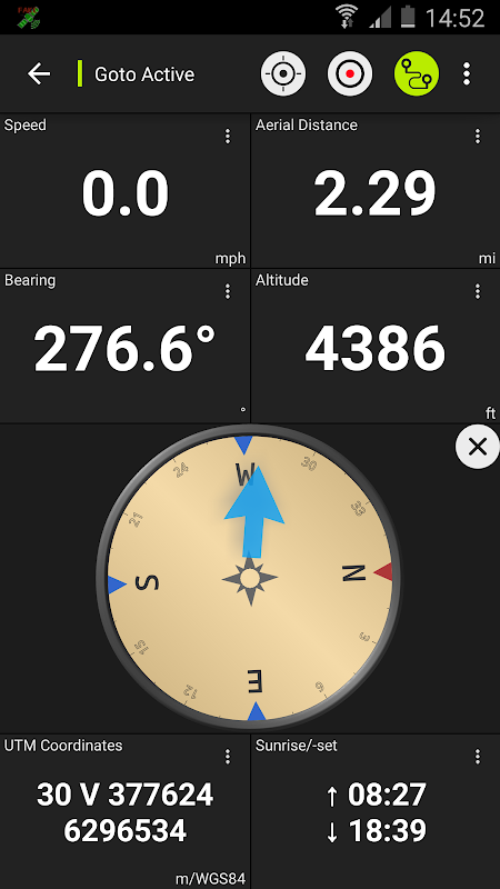
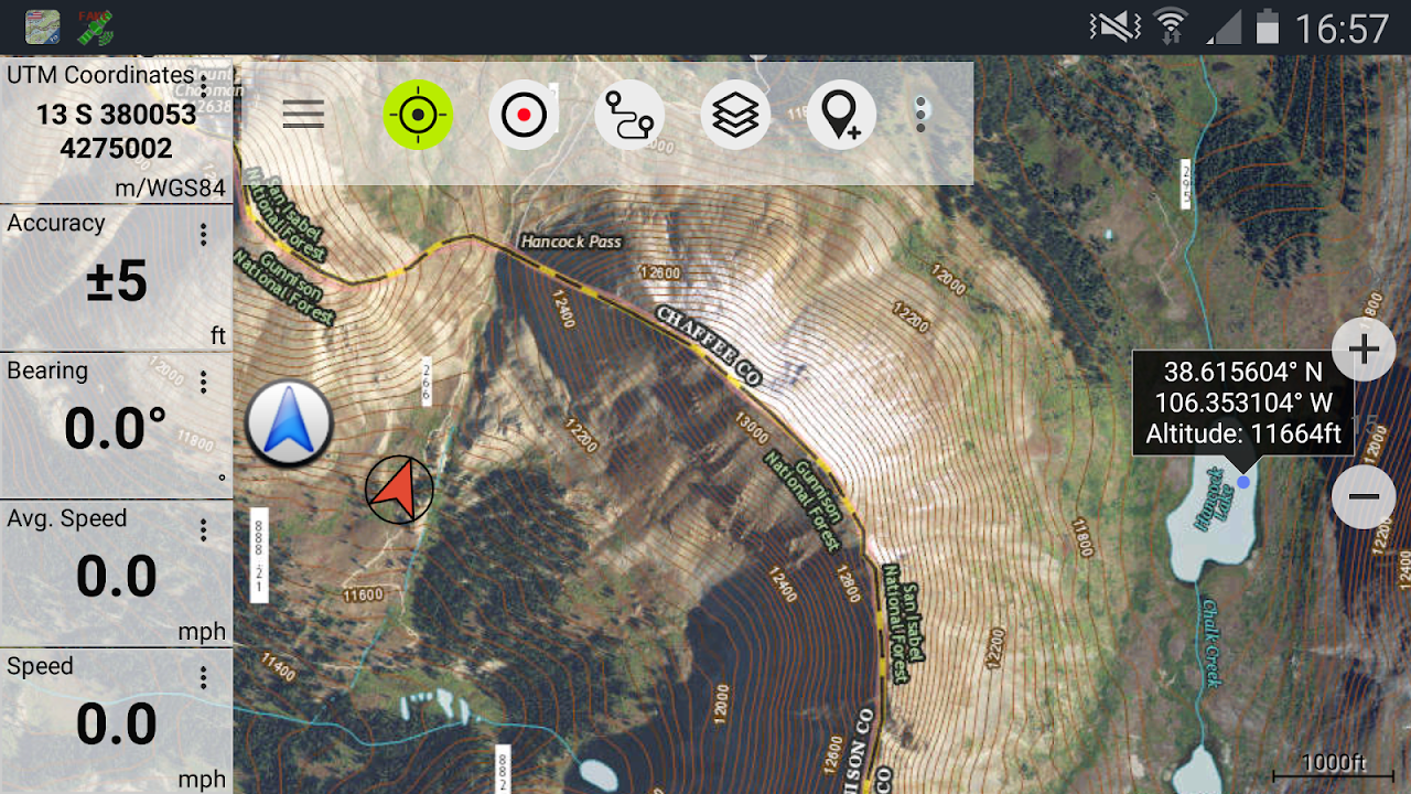
Screenshots


Description
GPS นำทางกลางแจ้งกับแผนที่ที่ดีที่สุดและภาพถ่ายทางอากาศออสเตรเลีย
Easy to use Outdoor/Offline GPS navigation app with access to the best topographic maps and satellite images for Australia.
++ For offline use PRO features needed ! ++
Turn your Andoid Phone/Tablet into an outdoor GPS for trips into the backcountry WITHOUT CELL COVERAGE. This app gives you similar mapping options as you might know from Garmin or Magellan GPS handhelds.
Included FREE map layers:
• NATMAP 1:250.000 Topo Maps, latest edition, enriched with hillshading and additional placenames !
• Australia Base Map: Seamless national dataset for whole of Australia. Very detailed !
• Queensland Topo Maps: High resolution topographic maps
• New South Wales Maps: High resolution topographic maps (scanned raster & digital) + HiRes Imagery
• Tasmania Maps: High resolution topographic maps + HiRes Imagery
• Northern Territory Atlas
• OpenStreetMaps : These crowdsourced maps are a very useful addition to other map layers. Contains many unique features.
• OpenCycleMaps: These maps are ideal to plan bicycle trips
• Geological Map (for biologists, geologists, miners, ...)
• ESRI Topographic
• ESRI Aerial Images
• ESRI Street Map
• Google Road Map (online access only)
• Google Satellite Images (online access only)
• Google Terrain Map (online access only)
• Bing Road Map (online access only)
• Bing Satellite Images (online access only)
• Earth At Night
• Hillshading overlay
• Transport/Infrastructure overlay
Premium Map layers:
• Victoria 1:25.000
For only 78,99 $ (AUD) you get unlimited access to all 25k Vic topo map sheets (865 maps !) - stitched together to a seamless mosaik (complete coverage) ! Easy to download and offline use ! Single GeoPDF map sheets cost 8,5$ at Vic DELWP office !
• Western Australia 1:25.000 - 1:100.000
For only 154,99 $ (AUD) you get unlimited access to all available 25k,50k and 100k WA topo map sheets (3044 maps!) - stitched together to a seamless mosaik ! Easy to download and offline use ! Single GeoPDF map sheets cost 12,6$ at WA Landgate office !
Main features for outdoor-navigation:
• Create and edit Waypoints
• GoTo-Waypoint-Navigation
• Track Recording (with speed, elevation and accuracy profile)
• Tripmaster with fields for odometer, average speed, bearing, elevation, etc.
• GPX/KML/KMZ Export
• Search (placenames, POIs, streets)
• Customizable datafields in Map View and Tripmaster (e.g. Speed, Distance, Compass, ...)
• Share Waypoints, Tracks or Routes (via eMail, Whatsapp, Dropbox, Facebook, ..)
• Display coordinates in Lat/Lon, UTM or MGRS/USNG (Military Grid/ US National Grid)
• Record & share tracks with statistics & elevation profile
• Rotate map (Track Up & North Up)
• Get Elevation by long click on map
• Track Replay
• and many more ...
Available Pro features: (Pro features available via In App Purchase)
• Offline Use - no cell coverage needed. No Roaming fees !
• Easy+Fast Bulk-download of map tiles for OFFLINE USAGE (not for Google and Bing maps)
• Create and edit Routes
• Route-Navigation (Point-to-Point Navigation)
• GPX/KML/KMZ Import
• unlimited Waypoints & Tracks
• Add other Map Tile-Server
• No Ads
Offline Use:
All viewed map tiles are kept in cache. To cache large areas you need to purchase Pro features.
Use this navigation app for outdoor activities like hiking, biking, camping, climbing, riding, skiing, canoeing, hunting, offroad 4WD tours or search&rescue (SAR).
Add custom waypoints in longitude/latitude, UTM or MGRS/USNG format with WGS84 datum.
Import/Export/Share GPS-Waypoints/Tracks/Routes in GPX or Google Earth KML/KMZ format.
Preload FREE map data for areas without cell service (Pro feature !).
Comments and feature requests to [email protected]
Have a look at our other outdoor navigation apps: https://play.google.com/store/search?q=atlogis
+++ We DO NOT track any user activities or collect any user data ! +++
ง่ายต่อการใช้กลางแจ้ง / ออฟไลน์ app นำทางจีพีเอสที่มีการเข้าถึงแผนที่ภูมิประเทศที่ดีที่สุดและภาพถ่ายจากดาวเทียมออสเตรเลีย
++ สำหรับการใช้งานแบบออฟไลน์คุณสมบัติ PRO จำเป็น! ++
เปิดโทรศัพท์ Andoid ของคุณ / แท็บเล็ตเป็นจีพีเอสกลางแจ้งสำหรับการเดินทางเข้าไปในเขตทุรกันดารโดยไม่มี CELL ประกัน app นี้ช่วยให้คุณเลือกทำแผนที่ที่คล้ายกันที่คุณอาจรู้จาก Garmin หรือ Magellan GPS อุปกรณ์พกพา
รวมเลเยอร์แผนที่ฟรี:
• NATMAP 1: 250.000 โทโปแผนที่ฉบับล่าสุดอุดมด้วย hillshading และ placenames เพิ่มเติม!
•ออสเตรเลียแผนที่ฐาน: ชุดประจำชาติแบบไม่มีรอยต่อทั้งของออสเตรเลีย รายละเอียดมาก!
•รัฐควีนส์แลนด์โทโปแผนที่: ความละเอียดสูงแผนที่ภูมิประเทศ
•นิวเซาธ์เวลส์แผนที่: ความละเอียดสูงแผนที่ภูมิประเทศ (raster สแกนและดิจิตอล) + ว่าจ้างจินตภาพ
•แทสมาเนียแผนที่: ความละเอียดสูงแผนที่ภูมิประเทศ + ว่าจ้างจินตภาพ
•เหนือดินแดน Atlas
• OpenStreetMaps: แผนที่ crowdsourced เหล่านี้ยังมีประโยชน์มากในการเลเยอร์แผนที่อื่น ๆ มีคุณสมบัติพิเศษหลาย
• OpenCycleMaps: แผนที่เหล่านี้เหมาะที่จะวางแผนการเดินทางจักรยาน
•แผนที่ธรณีวิทยา (สำหรับนักชีววิทยาธรณีวิทยาเหมือง, ... )
• ESRI ภูมิประเทศ
•ภาพ ESRI อากาศ
• ESRI Street Map
• Google แผนที่ถนน (เข้าถึงออนไลน์เท่านั้น)
• Google รูปภาพดาวเทียม (เข้าถึงออนไลน์เท่านั้น)
• Google แผนที่ภูมิประเทศ (เข้าถึงออนไลน์เท่านั้น)
• Bing แผนที่ถนน (เข้าถึงออนไลน์เท่านั้น)
•ภาพ Bing ดาวเทียม (เข้าถึงออนไลน์เท่านั้น)
•โลกในเวลากลางคืน
•ซ้อนทับ Hillshading
•ขนส่ง / โครงสร้างพื้นฐานซ้อนทับ
พรีเมี่ยมชั้นแผนที่:
•วิกตอเรีย 1: 25.000
เพียง 78,99 $ (AUD) คุณจะได้รับไม่ จำกัด การเข้าถึงทุก 25k วิกแผ่นแผนที่โทโป (865 แผนที่!) - เย็บเข้าด้วยกันกับ Mosaik ไร้รอยต่อ (คุ้มครองที่สมบูรณ์)! ง่ายต่อการดาวน์โหลดและออฟไลน์การใช้งาน! GeoPDF แผ่นแผนที่เดียวเสียค่าใช้จ่าย 8,5 $ ที่สำนักงานวิก DELWP!
•ออสเตรเลียตะวันตก 1: 25.000-1: 100.000
เพียง 154,99 $ (AUD) คุณจะได้รับไม่ จำกัด การเข้าถึง 25k ที่มีอยู่ทั้งหมด 50k และ 100k WA แผ่นแผนที่โทโป (3044 แผนที่!) - เย็บติดกันไปอย่างราบรื่น Mosaik! ง่ายต่อการดาวน์โหลดและออฟไลน์การใช้งาน! GeoPDF แผ่นแผนที่เดียวเสียค่าใช้จ่าย $ 12,6 ที่สำนักงาน WA Landgate!
คุณสมบัติหลักสำหรับกลางแจ้งนำทาง:
•สร้างและแก้ไข Waypoints
• GoTo-Waypoint นำร่อง
•ติดตามบันทึก (ด้วยความเร็วสูงและรายละเอียดความถูกต้อง)
• Tripmaster กับเขตข้อมูลสำหรับระยะทาง, ความเร็วเฉลี่ย, แบริ่งสูง ฯลฯ
• GPX / KML / KMZ ส่งออก
•การค้นหา (placenames, POIs ถนน)
• dataFields ปรับแต่งได้ในมุมมองแผนที่และ Tripmaster (เช่นความเร็ว, ระยะทาง, เข็มทิศ, ... )
•แบ่งปัน Waypoints, เพลงหรือเส้นทาง (ผ่านทางอีเมล, Whatsapp, Dropbox, Facebook, .. )
•จอแสดงผลในพิกัดละติจูด / ลองจิจูด, UTM หรือ MGRS / USNG (ทหารกริด / US กริดแห่งชาติ)
•บันทึกและแบ่งปันแทร็คที่มีสถิติและรายละเอียดการยกระดับ
•แผนที่หมุน (ติดตาม Up & Up นอร์ท)
•รับการยกระดับโดยการคลิกที่ยาวบนแผนที่
• Replay ติดตาม
• และอื่น ๆ อีกมากมาย ...
คุณสมบัติที่มีโปร (Pro คุณสมบัติสามารถใช้ได้ผ่านทาง App ในการซื้อ)
•ออฟไลน์ใช้งาน - การครอบคลุมของเซลล์ไม่จำเป็นต้อง ไม่มีค่าธรรมเนียมข้ามแดนอัตโนมัติ!
•ง่าย + ด่วน Bulk ดาวน์โหลดของกระเบื้องแผนที่ออฟไลน์การใช้งาน (ไม่ได้สำหรับ Google และ Bing Maps)
•สร้างและแก้ไขเส้นทาง
•เส้นทางนำร่อง (Point-to-Point นำร่อง)
• GPX / KML / KMZ นำเข้า
• Waypoints ไม่ จำกัด และเพลง
•เพิ่มแผนที่กระเบื้องเซิร์ฟเวอร์อื่น ๆ
•ไม่มีโฆษณา
การใช้งานแบบออฟไลน์:
กระเบื้องแผนที่ดูได้ทั้งหมดจะถูกเก็บไว้ในแคช แคชพื้นที่ขนาดใหญ่คุณจำเป็นต้องซื้อคุณสมบัติ Pro
ใช้นำทาง app นี้สำหรับกิจกรรมกลางแจ้งเช่นการเดินป่า, จักรยาน, ตั้งแคมป์, ปีนเขา, ขี่ม้า, สกี, พายเรือแคนูล่าออฟโร้ดทัวร์ 4WD หรือค้นหาและกู้ภัย (SAR)
เพิ่มจุดที่กำหนดเองในแวง / ละติจูด UTM หรือรูปแบบ MGRS / USNG กับ WGS84 ตัวเลข
นำเข้า / ส่งออก / หุ้นจีพีเอส Waypoints / เพลง / เส้นทางในรูปแบบ GPX หรือ Google Earth KML / KMZ
Preload ข้อมูลแผนที่ฟรีพื้นที่โดยบริการเซลล์ (คุณลักษณะ Pro!)
ความคิดเห็นและการร้องขอคุณสมบัติในการ [email protected]
มีลักษณะที่ปพลิเคชันนำทางกลางแจ้งอื่น ๆ ของเรา: https://play.google.com/store/search?q=atlogis
+++ เราไม่ติดตามกิจกรรมของผู้ใช้หรือเก็บรวบรวมข้อมูลผู้ใช้ใด ๆ ! +++
What's New
• Improvements & Fixes
Latest Version (Download)
Australia Topo Maps 2.0.1Date Updated : 2021-03-17
Advertisement
