Advertisement
Latest Version (Download)Table of Contents
Advertisement
Information
| Package | com.visualit.tubeLondonCity |
| Version | 2.7.0 |
| Date Updated | 2021-05-06 |
| Size | 5.64 MB |
| Installs | 4.4K+ |
| Categories | , |
Screenshots


Description
● KEY FEATURES ●
● Simple, fast and easy to use.
● Designed for the first time visitor and experienced commuter.
● Unique "Minute Map" feature provides a view of travel times from any location on the map.
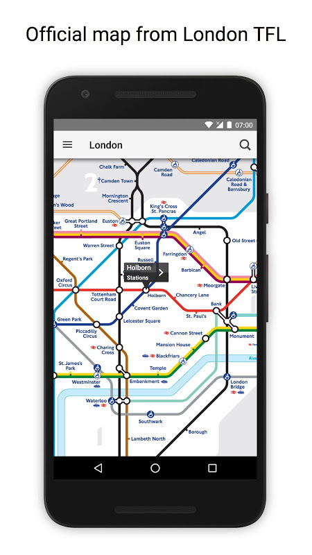
● Latest official TFL (Transport For London) tube map.
● Planned route animates on the tube map.
●.Switch to online street map (when an internet connection is available).
● Services can be turned on or off, routing around problems.
● Works in both landscape and portrait modes.
● Easily locates your nearest London transport stop.
● Places of interest, parks etc are built in to the application.
● Offline routing with clear map and text views
● GPS locating
● Station exit information
● Live service status and departure board information
● OVERVIEW ● The London Tube Map application is a superb route planner for the London Underground (Tube)system with many unique features. The inbuilt map provides the official TFL map of the city underground services with the ability to switch to an online street map view when an internet connection is available. This way the user can view the online map feature when above ground and the transport map and route planning is still fully functional underground or anywhere there is no internet connection. This provides the best of both worlds, the transport map and route planning anytime, anywhere and online street maps and search when a connection is available.
● ROUTING ● Does not require an internet connection and will always be available to display a clear and detailed view of the city transport system, plus list and animate the optimum route for your journey. Provides the fastest route calculations of any mobile routing application (virtually instantaneous) using actual published journey times with the ability to select the quickest route or the route with the least changes.
Comprehensive details of your planned route are provided, including changes, directions of travel, number of stops, predicted journey times, etc. Uniquely this application gives you “direction”, “towards” and “service frequency” information (not available on any other offline journey planner) for example “Take the Northern line (Southbound) towards Stockwell for 10 mins (6 stops). Service runs every 7 minutes” which is essential when finding the correct platform and connection. Also given are alternatives for each leg of the journey.
● NO INTERNET CONNECTION REQUIRED ● The tube map and routing do not require an internet connection and therefore you will not be charged data connection fees. This also means the application runs perfectly underground, on an aeroplane, etc. For international visitors to a city who have data roaming turned off this is an ideal solution.
● LIVE INFO ● When an internet connection is available, optional "Live Information" on the current state of the transport services and real time station departure boards can be viewed allowing you to plan your journeys in advance and avoid any potential delays. Unique to this application is the ability to turn off services that are out of action and automatically calculate an alternative route.
● MINUTE MAP ● This unique feature provides a view of travel times from any location on the map. This is helpful for getting a sense of scale and connectivity of the transport system and can provide some interesting results.
● MORE MAPS ● This map is one in a series of Zuti worldwide city maps, if you like this product you may also enjoy some of our other offerings, please visit www.zuti.co.uk for further information.● 주요 특징 ●
● 빠르고 간단하고 사용하기 쉽습니다.
● 처음 방문자와 경험 통근을 위해 설계되었습니다.
● 독특한 "세일지도 '기능은지도에서 모든 위치에서 여행 시간의보기를 제공합니다.
● 최신 공식 TFL (런던에 대한 전송) 관의지도.
● 계획 노선은 튜브지도에서 애니메이션.
(인터넷 연결을 사용할 수있는 경우) ●. 온라인 거리지도로 전환합니다.
● 서비스 또는 문제 주위 라우팅, 해제 할 수 있습니다.
● 가로 및 세로 모드 모두에서 작동합니다.
● 쉽게 가까운 런던 교통 정류장 찾습니다.
그 ● 장소는, 공원 등이 응용 프로그램에 내장되어 있습니다.
명확한지도 및 텍스트 전망 ● 오프라인 라우팅
● GPS 위치를 알아
● 역 출구 정보
● 라이브 서비스 상태 및 출발 보드 정보
● 런던 관의지도 응용 프로그램 ● 개관 많은 독특한 기능을 가진 런던 지하철 (튜브) 시스템에 대한 최상의 경로 플래너입니다. 붙박이지도는 인터넷 연결이 가능한 경우 온라인 거리지도보기로 전환 할 수있는 기능을 가진 도시의 지하 서비스의 공식 TFL지도를 제공한다. 사용자가 지상과 교통지도 및 노선 계획 위의 온라인지도 기능을 볼 수있는이 방법은 여전히 작동 지하 또는 어디에서든지 인터넷에 연결이 없습니다. 이것은 교통지도 및 노선 계획이 언제 어디서나 온라인 도로지도와 연결이 가능한 검색 두 세계의 최고를 제공합니다.
● 라우팅 ● 인터넷 연결을 필요로하지 않고, 항상 도시 교통 시스템의 명확하고 상세한보기를 표시 할 수있을 것입니다, 플러스 목록과 당신의 여행을위한 최적의 경로를 애니메이션. 최소한의 변화에 가장 빠른 경로 또는 경로를 선택할 수있는 능력과 실제 출판 여행 시간을 사용 (거의 순간) 모든 모바일 라우팅 응용 프로그램의 빠른 경로 계산을 제공합니다.
계획된 노선의 포괄적 인 세부 사항은 유일하게이 응용 프로그램은 당신에게 "방향을"제공은 다른에와 "서비스 주파수"정보 (사용할 수없는 "으로"등의 변경, 여행의 방향, 정지 횟수, 여행 시간을 예측 이용하실 수 있습니다 오프라인 여행 플래너) 예를 들어 "10 분 (6 정거장)에 대한 스톡웰 향해 북부 선 (사우스 바운드)를 가져 가라. 서비스 올바른 플랫폼과 연결을 찾을 때 필수적이다 매 7 분 "실행됩니다. 또한 여행의 각 다리에 대한 대안이있다 없습니다.
● 튜브지도 및 라우팅 ● 필요없이 인터넷 연결은 인터넷 연결을 필요로하지 않으며, 따라서 당신은 데이터 연결 요금이 청구되지 않습니다. 이것은 또한 응용 프로그램이 이상적인 솔루션입니다 해제 등 데이터 로밍이 도시에 국제 방문자를 들어, 비행기, 완벽하게 지하의 실행을 의미합니다.
인터넷 연결이 전송 서비스와 실시간 역 출발 보드의 현재 상태에서 사용할 수, 선택 "라이브 정보"의 경우 ● 라이브 정보 ● 당신이 사전에 여행을 계획하고 잠재적 인 지연을 방지 할 수 있도록 볼 수 있습니다. 이 응용 프로그램의 고유 한 행동 밖에있는 서비스를 해제하고 자동으로 대체 경로를 계산하는 기능입니다.
● 분 MAP의 ●이 독특한 기능은지도에서 모든 위치에서 여행 시간의보기를 제공합니다. 이 규모와 교통 시스템의 연결의 감각을 얻기위한 도움이되고 몇 가지 흥미로운 결과를 제공 할 수 있습니다.
● 더 MAPS ●이지도는이 제품처럼 당신은 또한 우리의 다른 제품을 즐길 수 있다면, 자세한 내용은 www.zuti.co.uk를 방문하시기 바랍니다, 즈티 세계 도시지도의 일련의 하나입니다.
What's New
2.2.5
● Fix for disappearing shortcut. If you still see this issue after updating, please try uninstalling and re-installing the application
2.2.4
● Latest map and routing
Latest Version (Download)
Tube Map London Underground 2.7.0Date Updated : 2021-05-06
Advertisement
