Advertisement
Latest Version (Download)Table of Contents
Advertisement
Information
| Package | com.huntstand.core |
| Version | 5.5 |
| Date Updated | 2021-04-28 |
| Size | 8.71 MB |
| Installs | 1.1K+ |
| Categories | Applicazioni, Sport |
Screenshots
Description
HuntStand, the #1 free hunting app in the world. Mapping, Weather, Scouting.
HuntStand, the #1 free hunting app in the world, is the only hunting and land management app you will ever need. This revolutionary app is packed with invaluable mapping, weather, tracking, and social features.
HuntStand was carefully designed to work in both online and offline environments. Using this app, you will have access to offline weather and maps of your hunt areas. You can edit your maps while out “in the field” then sync them with your HuntStand account.
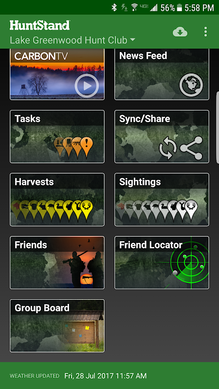
Use our Harvest, Sightings, and Task logging features to understand your property like never before.
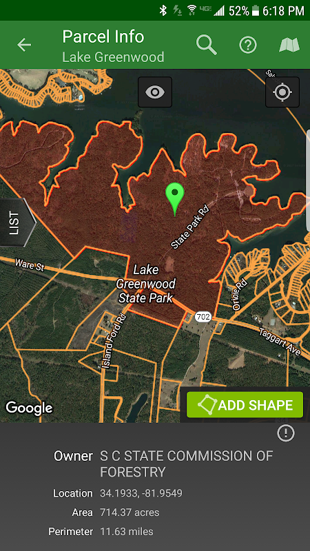
Access free property owner information and parcel boundary information for most of the country.
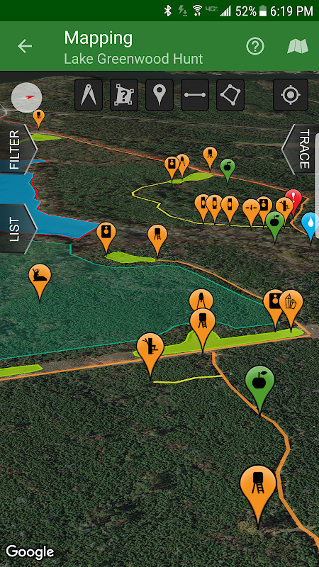
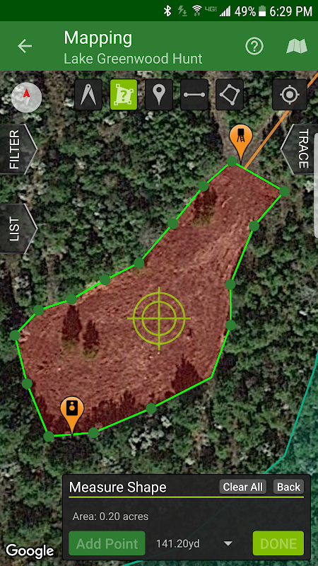
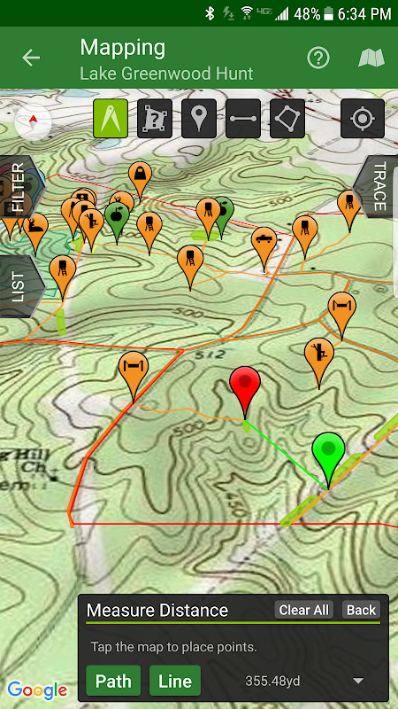
Fully map your property using 67 easily discernible custom icons, shapes, and lines including scouting marks, stands, property boundaries, food plots, ponds, roads, trails, and numerous other important objects of interest. Attach notes to your map objects and sort them by time and type.
View distance and area measurements using our advanced measurement tools. Our app will give you extremely accurate map-based distances in feet, meters, and yards and area measurements in acres.
HuntStand's interface is simple, yet powerful, and puts many useful tools right at your fingertips.
Create an account and gain the ability to:
-Sync Hunting Area maps with HuntStand.com
-View and edit maps using ultra-advanced on-line mapping features
-Share maps with friends
-Create a personal profile
-Join group hunting areas (allowing you to share and edit maps with your hunting friends)
-View advanced statistics built from your personal harvest and sighting history
-Sync your maps with other devices (Computers, tablets, phones, including both Android and iOS)
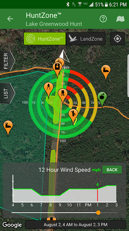
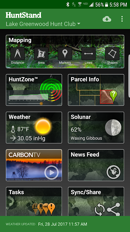
HuntStand features our revolutionary patent pending HuntZone technology. The HuntZone scent tool shows wind speed, direction, distance, and time in the most streamlined and efficient way possible. You can “slide” through wind forecasts and view the effects on your desired hunting area. The HuntZone tracks where your scent will be both at a specific time and throughout your hunt, allowing you to plan accordingly.
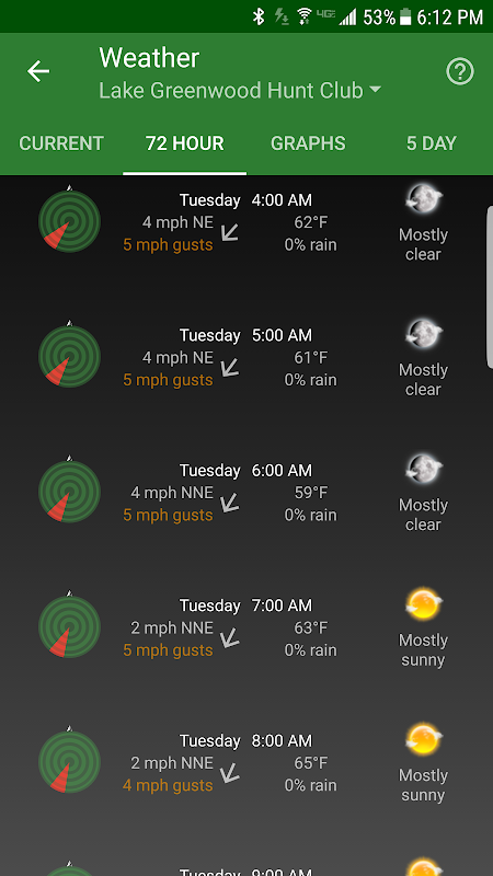
Have access to highly detailed weather and solunar information including a current weather page, (with useful charts) a 72 hour forecast, and a 5 day outlook.
HuntStand, powered by TerraStride, will revolutionize the way people hunt and operate in the outdoors.
HuntStand, il # 1 app caccia gratis in tutto il mondo, è l'unico caccia e la gestione del territorio app avrete mai bisogno. Questa applicazione rivoluzionaria è ricco di mappatura prezioso, il tempo, il monitoraggio, e le caratteristiche sociali.
HuntStand è stato accuratamente progettato per funzionare in entrambi gli ambienti online e offline. Utilizzando questa applicazione, si avrà accesso a tempo offline e mappe delle vostre zone di caccia. È possibile modificare le mappe mentre fuori "sul campo" per poi sincronizzare con il tuo account HuntStand.
Usa le nostre Harvest, VIP, e funzionalità di registrazione Task per capire la vostra proprietà come mai prima.
Accesso alla struttura proprietaria integrante le informazioni di confine per la maggior parte del paese.
Completamente mappare la struttura utilizzando 67 facilmente distinguibili icone personalizzate, forme e linee inclusi i segni di scouting, stand, confini di proprietà, trame alimentari, stagni, strade, sentieri, e numerosi altri oggetti importanti di interesse. Allegare note agli oggetti della mappa e ordinarli dal tempo e tipo.
Vista la distanza e le misure della superficie utilizzando i nostri strumenti di misurazione avanzati. La nostra applicazione vi darà estremamente precise distanze basate su mappe in piedi, metri, e cortili e misurazioni dell'area di acri.
L'interfaccia di HuntStand è semplice, ma potente, e mette molti strumenti utili a portata di mano.
Crea un account e acquisire la capacità di:
mappe -sync cacciare l'area con HuntStand.com
mappe -View e modificare utilizzando funzioni di mappatura ultra-avanzato in linea
mappe -Condividere con gli amici
-Creare Un profilo personale
aree di ricerca di gruppo -join (permettendo di condividere e modificare le mappe con i tuoi amici di caccia)
statistiche avanzate -View costruite dal tuo raccolto e avvistamento storia personale
-sync Le mappe con altri dispositivi (computer, tablet, telefoni, tra cui Android e iOS)
HuntStand dispone la nostra attesa di brevetto tecnologia rivoluzionaria HuntZone. Lo strumento HuntZone profumo mostra la velocità del vento, la direzione, la distanza e il tempo nella maniera più snella ed efficiente possibile. Si può "scivolare" attraverso vento e le previsioni visualizzare gli effetti sulla vostra zona di caccia desiderato. Il HuntZone piste dove il tuo profumo sarà sia in un momento specifico e per tutta la caccia, che consente di pianificare di conseguenza.
Avere accesso a tempo altamente dettagliato e le informazioni solunar compresa una pagina corrente tempo, (con grafici utili) una previsione 72 ore, e una prospettiva di 5 giorni.
HuntStand, alimentato da TerraStride, rivoluzionerà il caccia modo le persone e operare in mezzo alla natura.
What's New
- Now targeting Android 8.1
- Added a new Public Lands layer!
- The "Friends" feature has been fixed!
- Check out our new "Land For Sale" feature!
- The HuntZone feature should look pretty sharp now.
- "Show all" and "Hide all" added to the "Filter" available when Mapping for your convenience.
- Print your maps from HuntStand.com using a desktop browser!
- Feel free to write to [email protected] to report bugs and feature requests.
Latest Version (Download)
HuntStand 5.5Date Updated : 2021-04-28
Advertisement
