Advertisement
Latest Version (Download)Table of Contents
Advertisement
Information
| Package | com.huntstand.core |
| Version | 5.5 |
| Date Updated | 2021-02-23 |
| Size | 8.71 MB |
| Installs | 1.1K+ |
| Categories | Aplikasi, Olahraga |
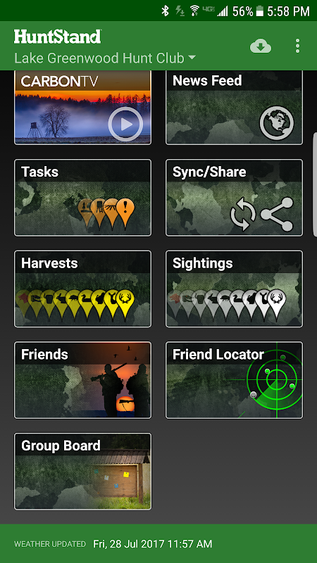
Screenshots
Description
HuntStand, the #1 free hunting app in the world. Mapping, Weather, Scouting.
HuntStand, the #1 free hunting app in the world, is the only hunting and land management app you will ever need. This revolutionary app is packed with invaluable mapping, weather, tracking, and social features.
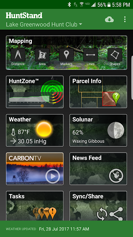
HuntStand was carefully designed to work in both online and offline environments. Using this app, you will have access to offline weather and maps of your hunt areas. You can edit your maps while out “in the field” then sync them with your HuntStand account.
Use our Harvest, Sightings, and Task logging features to understand your property like never before.
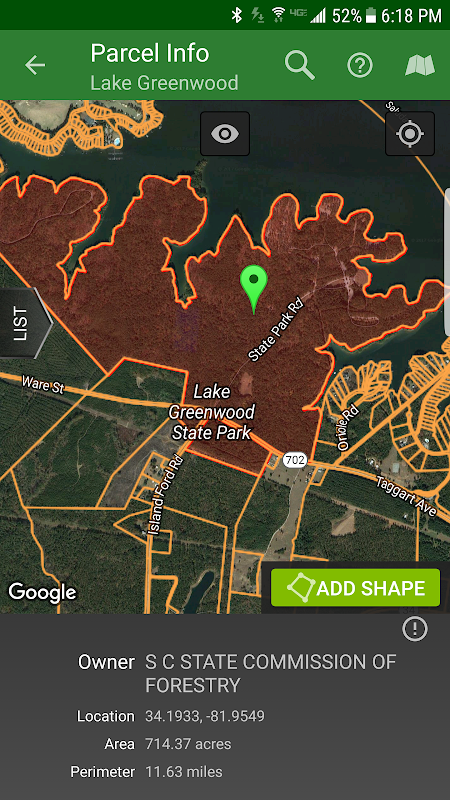
Access free property owner information and parcel boundary information for most of the country.
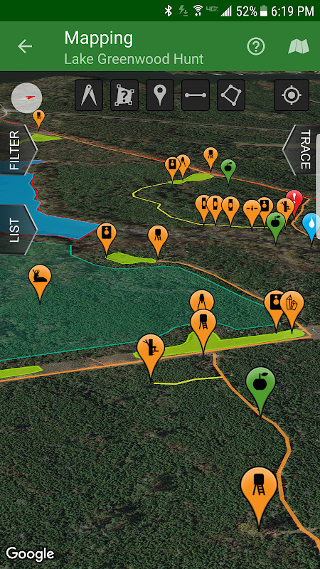
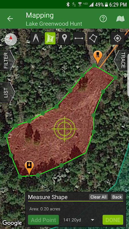
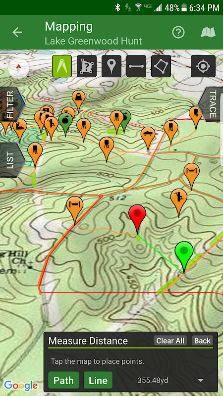
Fully map your property using 67 easily discernible custom icons, shapes, and lines including scouting marks, stands, property boundaries, food plots, ponds, roads, trails, and numerous other important objects of interest. Attach notes to your map objects and sort them by time and type.
View distance and area measurements using our advanced measurement tools. Our app will give you extremely accurate map-based distances in feet, meters, and yards and area measurements in acres.
HuntStand's interface is simple, yet powerful, and puts many useful tools right at your fingertips.
Create an account and gain the ability to:
-Sync Hunting Area maps with HuntStand.com
-View and edit maps using ultra-advanced on-line mapping features
-Share maps with friends
-Create a personal profile
-Join group hunting areas (allowing you to share and edit maps with your hunting friends)
-View advanced statistics built from your personal harvest and sighting history
-Sync your maps with other devices (Computers, tablets, phones, including both Android and iOS)
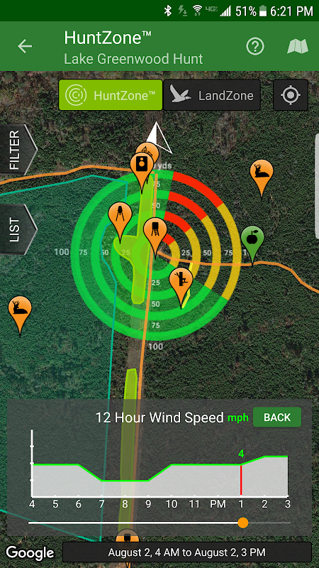
HuntStand features our revolutionary patent pending HuntZone technology. The HuntZone scent tool shows wind speed, direction, distance, and time in the most streamlined and efficient way possible. You can “slide” through wind forecasts and view the effects on your desired hunting area. The HuntZone tracks where your scent will be both at a specific time and throughout your hunt, allowing you to plan accordingly.
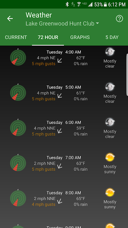
Have access to highly detailed weather and solunar information including a current weather page, (with useful charts) a 72 hour forecast, and a 5 day outlook.
HuntStand, powered by TerraStride, will revolutionize the way people hunt and operate in the outdoors.
HuntStand, # 1 aplikasi gratis berburu di dunia, adalah satu-satunya berburu dan pengelolaan lahan aplikasi yang Anda butuhkan. Aplikasi revolusioner ini dikemas dengan pemetaan berharga, cuaca, pelacakan, dan fitur sosial.
HuntStand hati-hati dirancang untuk bekerja baik dalam lingkungan online dan offline. Menggunakan aplikasi ini, Anda akan memiliki akses ke cuaca offline dan peta-peta daerah berburu Anda. Anda dapat mengedit peta Anda saat keluar "di bidang" kemudian menyelaraskannya dengan akun HuntStand Anda.
Gunakan Harvest, Sightings, dan fitur logging Tugas kita untuk memahami properti Anda tidak seperti sebelumnya.
Akses informasi pemilik properti gratis dan paket informasi batas untuk sebagian besar negara.
Sepenuhnya memetakan properti anda menggunakan 67 ikon dengan mudah dilihat kustom, bentuk, dan garis termasuk kepramukaan tanda, berdiri, batas-batas properti, plot makanan, kolam, jalan, jalan setapak, dan berbagai benda-benda penting lainnya yang menarik. Melampirkan catatan ke obyek peta dan mengurutkan mereka dengan waktu dan jenis.
Lihat jarak dan daerah pengukuran menggunakan alat ukur canggih. aplikasi kami akan memberikan sangat akurat jarak berbasis peta di kaki, meter, dan lapangan dan pengukuran daerah di acres.
antarmuka HuntStand sederhana, namun kuat, dan menempatkan banyak alat yang berguna tepat di ujung jari Anda.
Membuat account dan mendapatkan kemampuan untuk:
peta -Sync Hunting Lokasi dengan HuntStand.com
-Lihat Dan mengedit peta menggunakan ultra-canggih on-line fitur pemetaan
peta -Share dengan teman-teman
-Buat Profil pribadi
daerah perburuan kelompok -Join (yang memungkinkan Anda untuk berbagi dan mengedit peta dengan teman-teman Anda berburu)
statistik canggih -Lihat dibangun dari panen dan penampakan sejarah pribadi Anda
-Sync Peta Anda dengan perangkat lain (Komputer, tablet, ponsel, termasuk Android dan iOS)
HuntStand fitur revolusioner paten tertunda teknologi HuntZone kami. Alat HuntZone aroma menunjukkan kecepatan angin, arah, jarak, dan waktu dengan cara yang paling efisien dan efisien mungkin. Anda dapat "meluncur" melalui prakiraan angin dan melihat efek pada daerah berburu yang Anda inginkan. The HuntZone melacak di mana aroma Anda akan baik pada waktu tertentu dan seluruh berburu Anda, memungkinkan Anda untuk merencanakan sesuai.
Memiliki akses ke cuaca yang sangat rinci dan informasi pasang laut termasuk halaman saat cuaca, (dengan grafik berguna) perkiraan 72 jam, dan pandangan 5 hari.
HuntStand, didukung oleh TerraStride, akan merevolusi cara orang berburu dan beroperasi di luar ruangan.
What's New
- Now targeting Android 8.1
- Added a new Public Lands layer!
- The "Friends" feature has been fixed!
- Check out our new "Land For Sale" feature!
- The HuntZone feature should look pretty sharp now.
- "Show all" and "Hide all" added to the "Filter" available when Mapping for your convenience.
- Print your maps from HuntStand.com using a desktop browser!
- Feel free to write to [email protected] to report bugs and feature requests.
Latest Version (Download)
HuntStand 5.5Date Updated : 2021-02-23
Advertisement
