Advertisement
Latest Version (Download)Table of Contents
Advertisement
Information
| Package | net.binaryearth.handysurveying |
| Version | 6.3 |
| Date Updated | 2021-03-24 |
| Size | 1.72 MB |
| Installs | 139 |
| Categories | एप्लीकेशन, टूल्स |
Screenshots


Description
भूमि सर्वेक्षण के लिए एक व्यापक और आसान उपकरण का उपयोग करना
This app has been developed in consultation with experienced surveyors in both Australia and the US and includes many of the common Coordinate Geometry (COGO) calculations needed for land surveying field work.
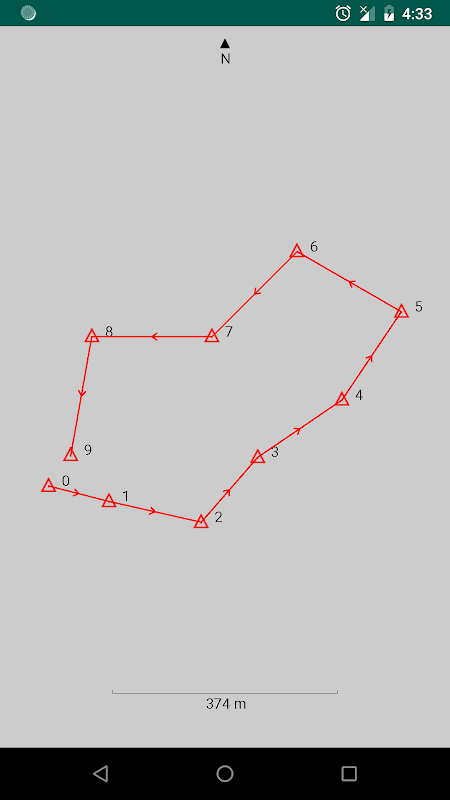
The app can store points for multiple jobs simultaneously, and can easily compute and store the next point on each leg of a continuous bearing and distance traverse. Once a traverse has been completed, it can be plotted, exported, and the misclosure can be computed and corrected if desired.
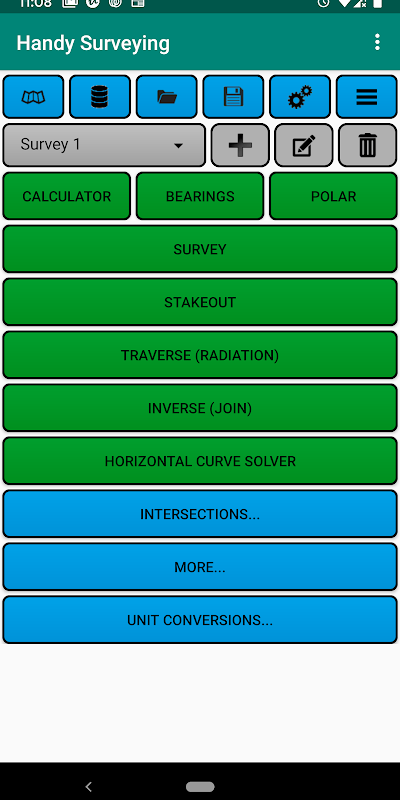
Functions include:
* Conduct a survey as a continuous traverse, automatically storing points in a point database
* Stakeout points on the ground from a plan
* Plot survey points
* List and edit survey point coordinates
* Import and export survey points from/to a CSV file
* Compute the misclosure distance and angle
* Automatically correct the misclosure using the Bowditch method.
* Compute enclosed area and perimeter
* Traverse / Radiation (2D and 3D)
* Inverse / Join (2D and 3D)
* Horizontal curve solver
* Intersection by bearings
* Intersection by distances
* Intersection by bearing and distance
* Intersection of two lines
* Intersection of perpendicular lines
* Point Scale Factor
* Grid Convergence
* General purpose calculator with trig functions and degree conversion tool
* Bearing calculator
* Polar to rectangular tool
* Units conversion tool
The app defaults to bearing entry and display in DD.MMSS format, but you can also select D/M/S or Decimal Degrees (Dec Deg) formats. You can also choose for northings to appear before eastings using an option on the preferences page.
इस ऐप को ऑस्ट्रेलिया और अमेरिका दोनों में अनुभवी सर्वेक्षकों के परामर्श से विकसित किया गया है और इसमें भूमि सर्वेक्षण क्षेत्र के काम के लिए आवश्यक कई सामान्य समन्वय ज्यामिति (COGO) गणना शामिल हैं।
एप्लिकेशन एक साथ कई नौकरियों के लिए अंक स्टोर कर सकता है, और एक निरंतर असर और दूरी के निशान के प्रत्येक पैर पर अगले बिंदु को आसानी से गणना और संग्रहीत कर सकता है। एक बार जब कोई निशान पूरा हो गया है, तो उसे साजिश रची जा सकती है, निर्यात किया जा सकता है, और यदि वांछित है तो मिसकॉल को गणना और सही किया जा सकता है।
कार्यों में शामिल हैं:
* एक निरंतर यात्रा के रूप में एक सर्वेक्षण का संचालन करें, स्वचालित रूप से एक बिंदु डेटाबेस में अंक संग्रहीत करना
* एक योजना से जमीन पर अंकन
* प्लॉट सर्वेक्षण बिंदु
* सूची बिंदु संपादित करें और सर्वेक्षण बिंदु निर्देशांक
* CSV फ़ाइल से / के लिए आयात और निर्यात सर्वेक्षण बिंदु
* मिसकॉल दूरी और कोण की गणना करें
* बॉडीच विधि का उपयोग करके स्वचालित रूप से मिसकॉल को ठीक करें।
* गणना संलग्न क्षेत्र और परिधि
* ट्रैवर्स / विकिरण (2 डी और 3 डी)
* उलटा / शामिल (2 डी और 3 डी)
* क्षैतिज वक्र सॉल्वर
* बीयरिंगों द्वारा प्रतिच्छेदन
* दूरियों से अंतर्मन
* असर और दूरी से अंतर
* दो रेखाओं का परस्पर संबंध
* लंबवत रेखाओं का अंतर्विरोध
* प्वाइंट स्केल फैक्टर
* ग्रिड कन्वर्जेंस
* ट्रिगर कार्यों और डिग्री रूपांतरण उपकरण के साथ सामान्य उद्देश्य कैलकुलेटर
* असर कैलकुलेटर
* आयताकार उपकरण के लिए ध्रुवीय
* इकाइयों रूपांतरण उपकरण
एप्लिकेशन डीडीएमएमएसएस प्रारूप में प्रविष्टि और प्रदर्शन को प्रभावित करने के लिए चूक करता है, लेकिन आप डी / एम / एस या दशमलव डिग्री (डीईसी डीजी) प्रारूप भी चुन सकते हैं। आप वरीयताएँ पृष्ठ पर एक विकल्प का उपयोग करके उत्तर-पूर्व के लिए उत्तर-पूर्व का चयन करने के लिए भी चुन सकते हैं।
What's New
3.8: Buttons and drop-down lists now use black text in dark mode instead of white.
3.7: Added a dark mode option on the preferences page.
3.6: Added a drop-down to select the units of your survey when exporting survey points to KML.
3.5: Added an option to the main page menu to export the survey points to a KML file for viewing in Google Earth.
Latest Version (Download)
Handy Surveying 6.3Date Updated : 2021-03-24
Advertisement
