Advertisement
Latest Version (Download)Table of Contents
Advertisement
Information
| Package | com.huntstand.core |
| Version | 5.5 |
| Date Updated | 2021-02-23 |
| Size | 8.71 MB |
| Installs | 1.1K+ |
| Categories | Aplicaciones, Deportes |
Screenshots
Description
HuntStand, la aplicación de la caza libre # 1 en el mundo. Mapeo, tiempo, el Movimiento Scout.
HuntStand, the #1 free hunting app in the world, is the only hunting and land management app you will ever need. This revolutionary app is packed with invaluable mapping, weather, tracking, and social features.
HuntStand was carefully designed to work in both online and offline environments. Using this app, you will have access to offline weather and maps of your hunt areas. You can edit your maps while out “in the field” then sync them with your HuntStand account.
Use our Harvest, Sightings, and Task logging features to understand your property like never before.
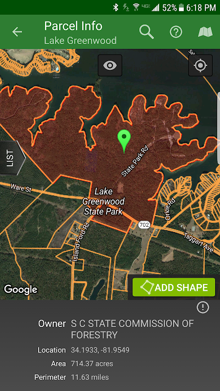
Access free property owner information and parcel boundary information for most of the country.
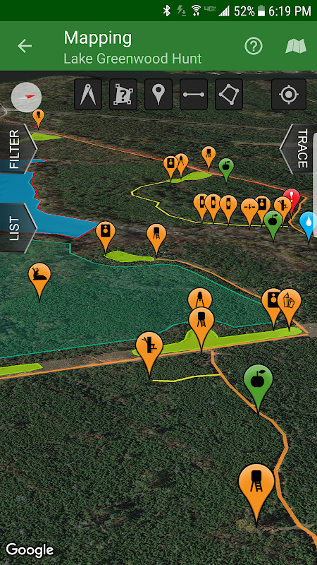
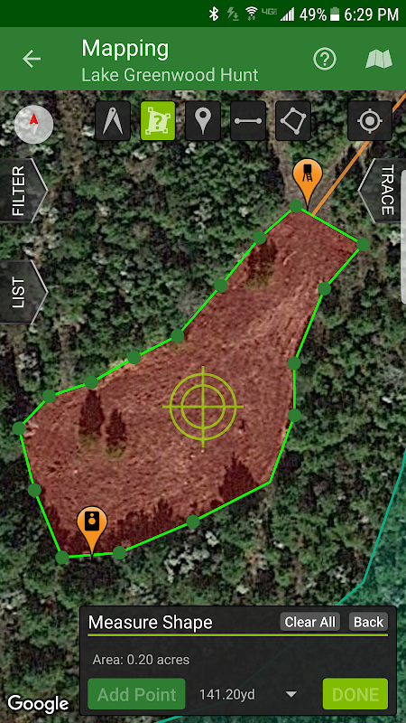
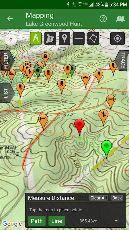
Fully map your property using 67 easily discernible custom icons, shapes, and lines including scouting marks, stands, property boundaries, food plots, ponds, roads, trails, and numerous other important objects of interest. Attach notes to your map objects and sort them by time and type.
View distance and area measurements using our advanced measurement tools. Our app will give you extremely accurate map-based distances in feet, meters, and yards and area measurements in acres.
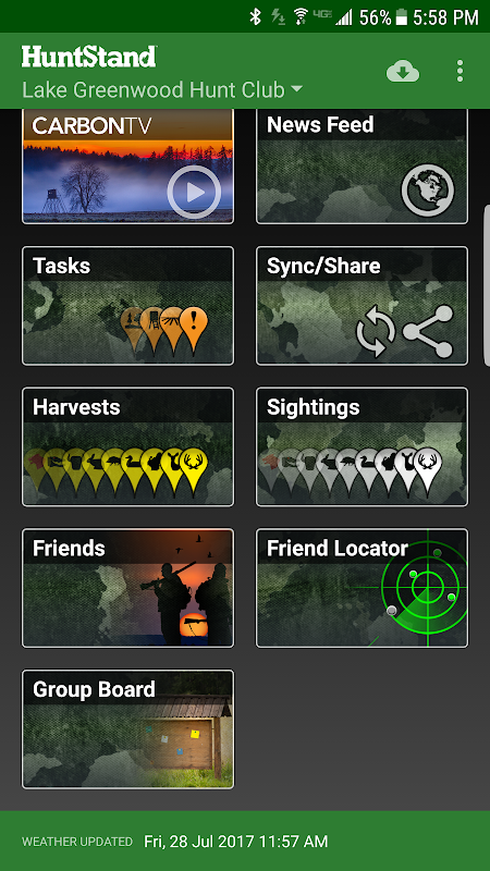
HuntStand's interface is simple, yet powerful, and puts many useful tools right at your fingertips.
Create an account and gain the ability to:
-Sync Hunting Area maps with HuntStand.com
-View and edit maps using ultra-advanced on-line mapping features
-Share maps with friends
-Create a personal profile
-Join group hunting areas (allowing you to share and edit maps with your hunting friends)
-View advanced statistics built from your personal harvest and sighting history
-Sync your maps with other devices (Computers, tablets, phones, including both Android and iOS)
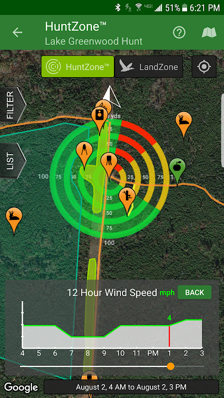
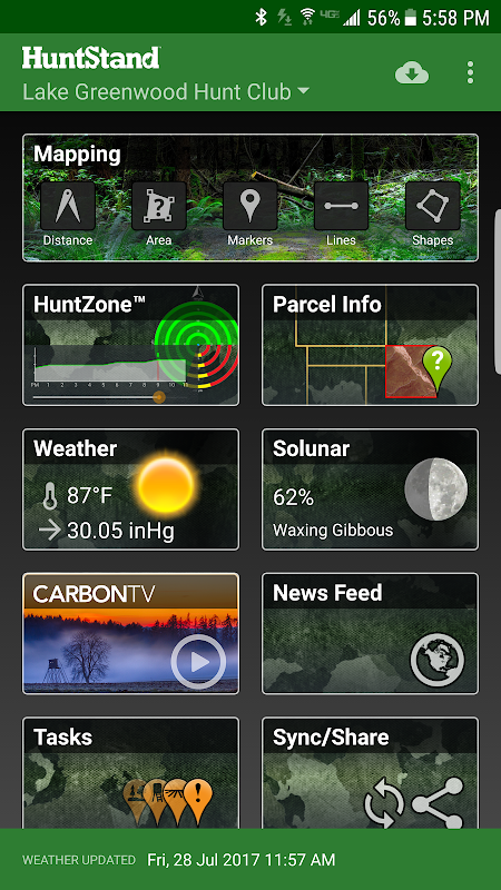
HuntStand features our revolutionary patent pending HuntZone technology. The HuntZone scent tool shows wind speed, direction, distance, and time in the most streamlined and efficient way possible. You can “slide” through wind forecasts and view the effects on your desired hunting area. The HuntZone tracks where your scent will be both at a specific time and throughout your hunt, allowing you to plan accordingly.
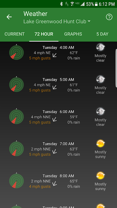
Have access to highly detailed weather and solunar information including a current weather page, (with useful charts) a 72 hour forecast, and a 5 day outlook.
HuntStand, powered by TerraStride, will revolutionize the way people hunt and operate in the outdoors.
HuntStand, la aplicación de la caza libre # 1 en el mundo, es la única aplicación de la caza y la gestión de la tierra que usted necesitará siempre. Esta revolucionaria aplicación está repleto de mapeo de gran valor, el tiempo, el seguimiento, y las características sociales.
HuntStand fue cuidadosamente diseñado para trabajar tanto en entornos en línea y fuera de línea. El uso de esta aplicación, usted tendrá acceso a la línea del tiempo y mapas de sus áreas de caza. Usted puede editar sus mapas mientras que hacia fuera "en el campo" y luego sincronizarlos con su cuenta de HuntStand.
Utilice nuestra cosecha, vistas, y funciones de registro de tareas para entender su propiedad como nunca antes.
Acceso prohibido información del propietario y la información de límite de parcela para la mayor parte del país.
mapa completamente su establecimiento a través de 67 iconos fácilmente discernibles personalizados, formas y líneas de exploración, incluyendo marcas, stands, los límites de propiedad, los bancos de proteína, estanques, caminos, senderos y numerosos otros objetos importantes de interés. Adjuntar notas a sus objetos de mapa y ordenarlos por fecha y tipo.
Ver la distancia y mediciones de área utilizando nuestras herramientas de medición avanzadas. Nuestra aplicación le dará distancias extremadamente precisos basados en mapas en pies, metros y yardas y mediciones de área en acres.
La interfaz del HuntStand es simple, pero potente, y pone muchas herramientas útiles a su alcance.
Crear una cuenta y obtener la capacidad de:
-sync Área de caza con los mapas de HuntStand.com
-Ver y editar mapas utilizando las funciones de mapeo ultra-avanzada en línea
-Compartir mapas con los amigos
A crear un perfil personal
áreas de caza en grupo -join (que le permite compartir y editar mapas con sus amigos de caza)
-Ver Estadísticas avanzadas construidas a partir de su cosecha y avistamiento historia personal
-sync Sus mapas con otros dispositivos (ordenadores, tabletas, teléfonos, incluyendo Android y iOS)
HuntStand cuenta con nuestra revolucionaria tecnología pendiente de patente HuntZone. La herramienta HuntZone aroma muestra la velocidad del viento, dirección, distancia y tiempo de la manera más racional y eficiente posible. Usted puede "deslizarse" a través de previsiones de viento y ver los efectos en su zona de caza deseada. El HuntZone un seguimiento de dónde está su aroma será a la vez en un momento determinado ya lo largo de su caza, lo que le permite planificar en consecuencia.
Tener acceso a un clima muy detallada e información solunar incluyendo una página actual del tiempo, (con gráficos útiles) una previsión de 72 horas, y una perspectiva de 5 días.
HuntStand, impulsado por TerraStride, revolucionará la manera como la gente caza y operar en el aire libre.
What's New
- Now targeting Android 8.1
- Added a new Public Lands layer!
- The "Friends" feature has been fixed!
- Check out our new "Land For Sale" feature!
- The HuntZone feature should look pretty sharp now.
- "Show all" and "Hide all" added to the "Filter" available when Mapping for your convenience.
- Print your maps from HuntStand.com using a desktop browser!
- Feel free to write to [email protected] to report bugs and feature requests.
Latest Version (Download)
HuntStand 5.5Date Updated : 2021-02-23
Advertisement
