Advertisement
Latest Version (Download)Table of Contents
Advertisement
Information
| Package | com.huntstand.core |
| Version | 5.5 |
| Date Updated | 2021-01-31 |
| Size | 8.71 MB |
| Installs | 1K+ |
| Categories | Anwendungen, Sport |
Screenshots
Description
HuntStand, the #1 free hunting app in the world. Mapping, Weather, Scouting.
HuntStand, the #1 free hunting app in the world, is the only hunting and land management app you will ever need. This revolutionary app is packed with invaluable mapping, weather, tracking, and social features.
HuntStand was carefully designed to work in both online and offline environments. Using this app, you will have access to offline weather and maps of your hunt areas. You can edit your maps while out “in the field” then sync them with your HuntStand account.
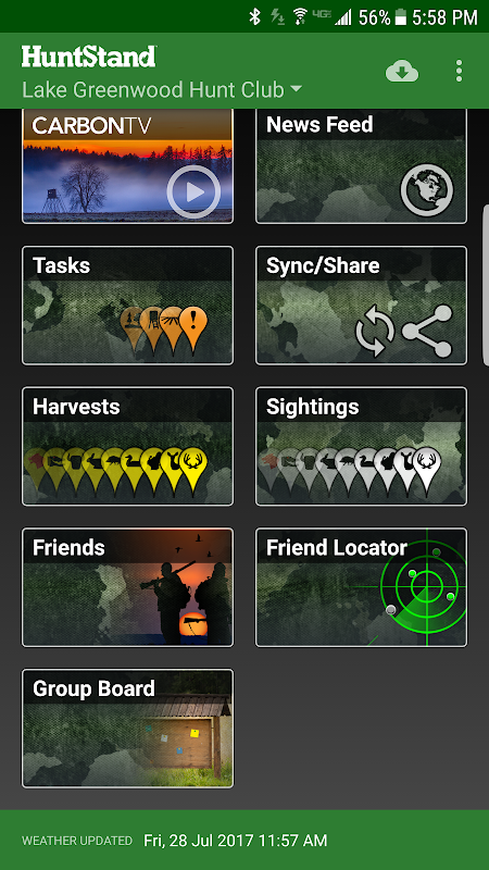
Use our Harvest, Sightings, and Task logging features to understand your property like never before.
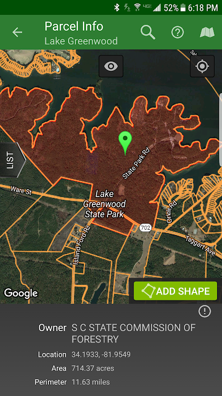
Access free property owner information and parcel boundary information for most of the country.
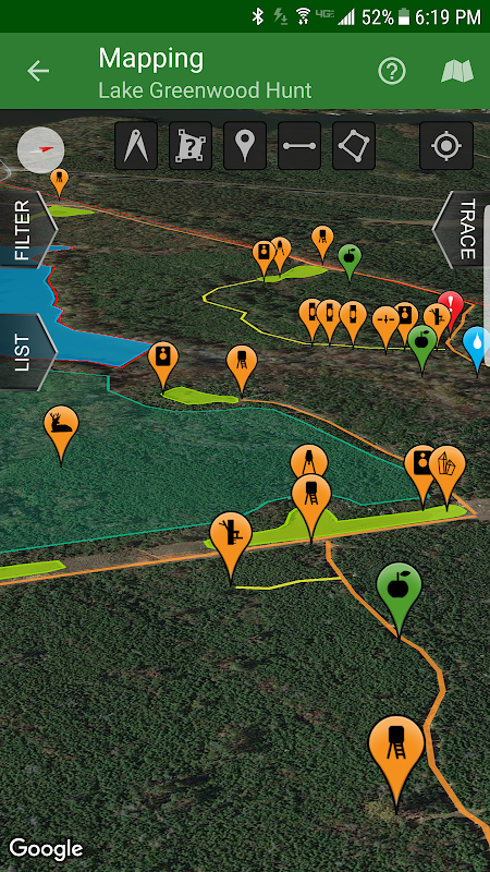
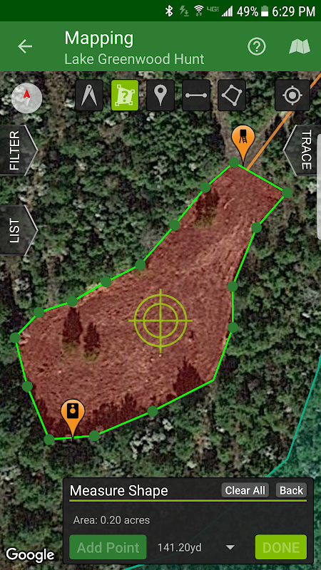
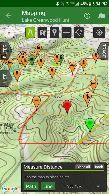
Fully map your property using 67 easily discernible custom icons, shapes, and lines including scouting marks, stands, property boundaries, food plots, ponds, roads, trails, and numerous other important objects of interest. Attach notes to your map objects and sort them by time and type.
View distance and area measurements using our advanced measurement tools. Our app will give you extremely accurate map-based distances in feet, meters, and yards and area measurements in acres.
HuntStand's interface is simple, yet powerful, and puts many useful tools right at your fingertips.
Create an account and gain the ability to:
-Sync Hunting Area maps with HuntStand.com
-View and edit maps using ultra-advanced on-line mapping features
-Share maps with friends
-Create a personal profile
-Join group hunting areas (allowing you to share and edit maps with your hunting friends)
-View advanced statistics built from your personal harvest and sighting history
-Sync your maps with other devices (Computers, tablets, phones, including both Android and iOS)
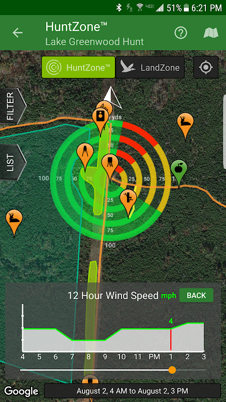
HuntStand features our revolutionary patent pending HuntZone technology. The HuntZone scent tool shows wind speed, direction, distance, and time in the most streamlined and efficient way possible. You can “slide” through wind forecasts and view the effects on your desired hunting area. The HuntZone tracks where your scent will be both at a specific time and throughout your hunt, allowing you to plan accordingly.
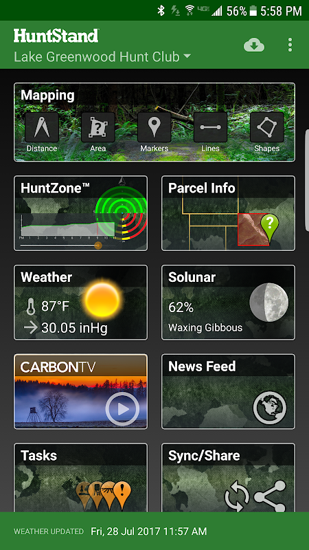
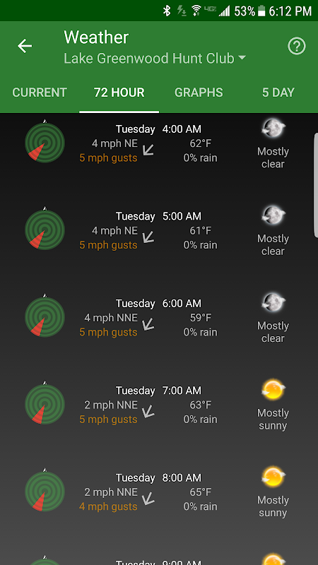
Have access to highly detailed weather and solunar information including a current weather page, (with useful charts) a 72 hour forecast, and a 5 day outlook.
HuntStand, powered by TerraStride, will revolutionize the way people hunt and operate in the outdoors.
HuntStand, die Nummer 1 der kostenlosen App Jagd in der Welt, ist die einzige Jagd und Landmanagement App, die Sie jemals brauchen werden. Diese revolutionäre App ist mit unschätzbarem Wert Mapping, Wetter, Tracking verpackt und soziale Funktionen.
HuntStand wurde sorgfältig in sowohl online als auch offline Umgebungen konzipiert. Mit dieser App haben Sie Zugriff auf Offline-Wetter haben und Karten Ihrer Jagd Bereiche. Sie können Ihre Karten während out "im Feld" sie dann mit Ihrem HuntStand Konto synchronisieren bearbeiten.
Nutzen Sie unsere Ernte, Sichtungen und Task-Logging-Funktionen, um Ihre Eigenschaft zu verstehen, wie nie zuvor.
Zugang Unterkunft Eigentümerinformationen und Paketgrenzinformation für den größten Teil des Landes.
Karte Voll Ihre Immobilie mit 67 leicht erkennbar benutzerdefinierte Symbole, Formen und Linien einschließlich Scouting Marken steht, Grundstücksgrenzen, Lebensmittel-Plots, Teiche, Straßen, Wege und zahlreiche andere wichtige Objekte von Interesse. Bringen Sie Hinweise auf Ihre Kartenobjekte und sortieren sie nach Zeit und Art.
Ansicht Abstand und Flächenmessungen unserem erweiterten Messtools. Unsere App wird Ihnen eine extrem genaue kartenbasierte Entfernungen in Fuß, Meter und Yards und Flächenmessungen in Acres.
HuntStand Benutzeroberfläche ist einfach und doch leistungsstark und bringt viele nützliche Werkzeuge direkt zur Hand.
Erstellen Sie ein Konto und die Fähigkeit erlangen, zu:
-sync Hunting Area Karten mit HuntStand.com
-Ansicht Und bearbeiten Karten Online-Mapping-Funktionen extrem erweiterte Verwendung
-Aktie Karten mit Freunden
-Mit Persönliches Profil
-join Gruppe Jagdgebiete (so dass Sie zu teilen und bearbeiten Karten mit Ihrem Jagdfreunde)
-Ansicht Erweiterte Statistiken aus Ihrer persönlichen Ernte und Sichtung Geschichte gebaut
-sync Ihre Karten mit anderen Geräten (Computer, Tablets, Handys, einschließlich Android und iOS)
HuntStand verfügt über unsere revolutionäre zum Patent angemeldete HuntZone Technologie. Der HuntZone Duft Werkzeug zeigt Windgeschwindigkeit, Richtung, Entfernung und Zeit in den meisten schlanken und effizienten Art und Weise möglich. Sie können "gleiten" durch Windprognosen und die Auswirkungen auf das gewünschte Jagdrevier anzuzeigen. Die HuntZone Tracks, wo Duft sowohl zu einem bestimmten Zeitpunkt sein wird, und während Ihrer Jagd, so dass Sie entsprechend planen.
Haben Sie Zugriff auf sehr detaillierte Wetter und unter unseren Füßen Informationen, einschließlich einer aktuellen Wetterseite (mit nützlichen Diagrammen) einem 72-Stunden-Vorhersage und einer 5-Tage-Trend.
HuntStand, angetrieben durch TerraStride, wird die Art und Weise Menschen Jagd revolutionieren und in der freien Natur zu betreiben.
What's New
- Now targeting Android 8.1
- Added a new Public Lands layer!
- The "Friends" feature has been fixed!
- Check out our new "Land For Sale" feature!
- The HuntZone feature should look pretty sharp now.
- "Show all" and "Hide all" added to the "Filter" available when Mapping for your convenience.
- Print your maps from HuntStand.com using a desktop browser!
- Feel free to write to [email protected] to report bugs and feature requests.
Latest Version (Download)
HuntStand 5.5Date Updated : 2021-01-31
Advertisement
