Advertisement
احدث اصدارجدول المحتويات
Advertisement
المعلومات
| Package | com.huntstand.core |
| الاصدار | 5.5 |
| تاريخ التحديث | 2021-01-31 |
| الحجم | 8.71 MB |
| التحميلات | 1K+ |
| الاقسام | تطبيقات, الرياضة |
لقطات الشاشة
الوصف
HuntStand, the #1 free hunting app in the world. Mapping, Weather, Scouting.
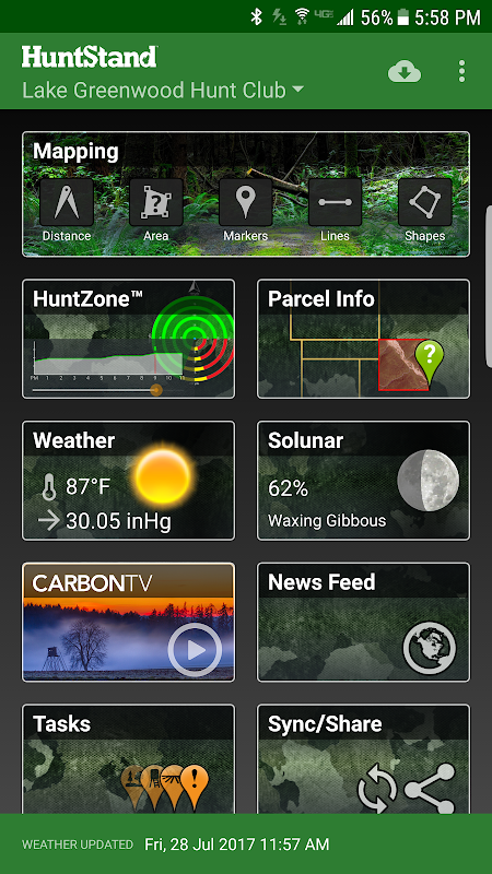
HuntStand, the #1 free hunting app in the world, is the only hunting and land management app you will ever need. This revolutionary app is packed with invaluable mapping, weather, tracking, and social features.
HuntStand was carefully designed to work in both online and offline environments. Using this app, you will have access to offline weather and maps of your hunt areas. You can edit your maps while out “in the field” then sync them with your HuntStand account.
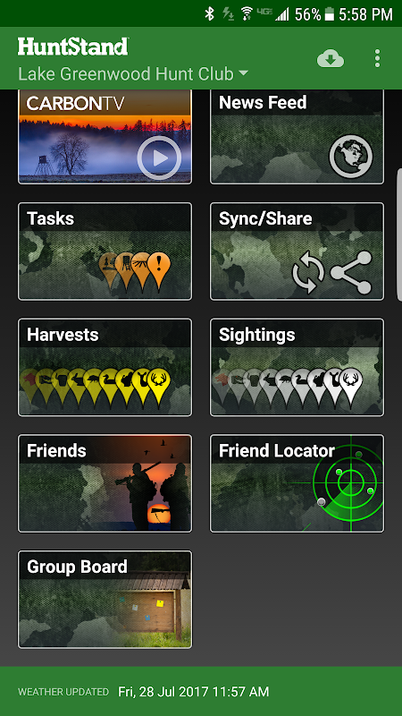
Use our Harvest, Sightings, and Task logging features to understand your property like never before.
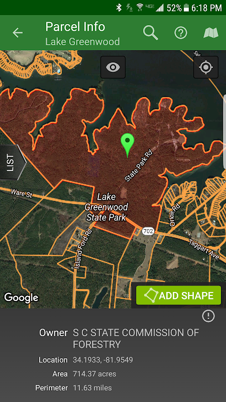
Access free property owner information and parcel boundary information for most of the country.
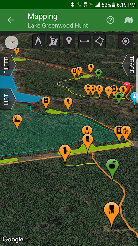
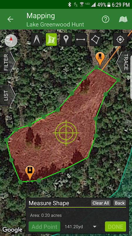
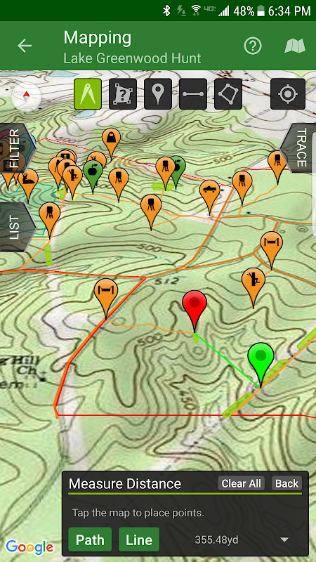
Fully map your property using 67 easily discernible custom icons, shapes, and lines including scouting marks, stands, property boundaries, food plots, ponds, roads, trails, and numerous other important objects of interest. Attach notes to your map objects and sort them by time and type.
View distance and area measurements using our advanced measurement tools. Our app will give you extremely accurate map-based distances in feet, meters, and yards and area measurements in acres.
HuntStand's interface is simple, yet powerful, and puts many useful tools right at your fingertips.
Create an account and gain the ability to:
-Sync Hunting Area maps with HuntStand.com
-View and edit maps using ultra-advanced on-line mapping features
-Share maps with friends
-Create a personal profile
-Join group hunting areas (allowing you to share and edit maps with your hunting friends)
-View advanced statistics built from your personal harvest and sighting history
-Sync your maps with other devices (Computers, tablets, phones, including both Android and iOS)
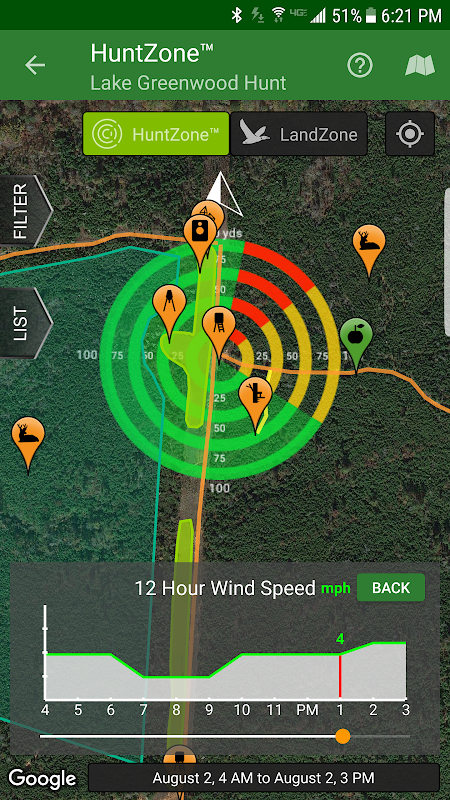
HuntStand features our revolutionary patent pending HuntZone technology. The HuntZone scent tool shows wind speed, direction, distance, and time in the most streamlined and efficient way possible. You can “slide” through wind forecasts and view the effects on your desired hunting area. The HuntZone tracks where your scent will be both at a specific time and throughout your hunt, allowing you to plan accordingly.
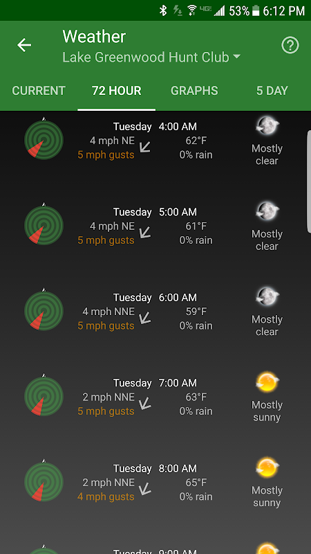
Have access to highly detailed weather and solunar information including a current weather page, (with useful charts) a 72 hour forecast, and a 5 day outlook.
HuntStand, powered by TerraStride, will revolutionize the way people hunt and operate in the outdoors.
HuntStand، # 1 التطبيق الصيد الحر في العالم، هو الصيد وإدارة الأراضي الوحيد التطبيق ستحتاج أي وقت مضى. هي معبأة هذا التطبيق الثوري مع تعيين لا تقدر بثمن، والطقس، وتتبع، والخصائص الاجتماعية.
وقد تم تصميم HuntStand بعناية للعمل في بيئات الانترنت وغير متصل على حد سواء. باستخدام هذا التطبيق، سيكون لديك الوصول إلى حاليا الطقس وخرائط للمناطق مطاردة الخاص. يمكنك تعديل الخرائط الخاصة بك بينما خارجا "في الميدان" ثم مزامنة لهم حساب HuntStand الخاص بك.
استخدام لدينا الحصاد، مشاهد، وميزات تسجيل العمل لفهم الممتلكات الخاصة بك كما لم يحدث من قبل.
وصول بيانات مالك العقار ومعلومات مجانية للحدود لا يتجزأ عن معظم أنحاء البلاد.
خريطة بالكامل الممتلكات الخاصة بك باستخدام 67 الرموز اضحة بسهولة حسب الطلب، والأشكال، والخطوط بما في ذلك علامات الكشفية، وتقف، حدود الملكية، قطع الغذاء والبرك والطرق والممرات، والعديد من الكائنات الأخرى الهامة ذات الاهتمام. إرفاق الملاحظات على الأشياء الخريطة وفرزها حسب الوقت ونوع.
عرض المسافة وقياسات المنطقة باستخدام لدينا أدوات القياس المتقدمة. سيكون لدينا التطبيق تعطيك مسافات دقيقة للغاية على أساس خريطة في القدمين، متر، وساحات وقياسات المنطقة فدان.
واجهة HuntStand هي بسيطة، لكنها قوية، ويضع العديد من الأدوات المفيدة الحق في متناول يدك.
إنشاء حساب واكتساب القدرة على:
خرائط -Sync الصيد المساحة مع HuntStand.com
خرائط -عرض وتحرير استخدام ميزات الخرائط على الخط المتطور
خرائط -Share مع الأصدقاء
-يمكنك إنشاء ملف شخصي
مناطق الصيد مجموعة -Join (مما يسمح لك لتبادل وتحرير الخرائط مع الأصدقاء الصيد الخاصة بك)
إحصائيات متقدمة -عرض بنيت من الشخصية الخاصة بك الحصاد ورؤية التاريخ
-Sync الخرائط الخاصة بك مع غيرها من الأجهزة (أجهزة الكمبيوتر، وأقراص، والهواتف، بما في ذلك Android و iOS)
HuntStand يتميز دينا الثورية براءات الاختراع في انتظار التكنولوجيا HuntZone. تظهر أداة HuntZone رائحة سرعة الرياح واتجاهها، وبعد المسافة، والوقت في الطريق الأكثر تنظيما وكفاءة ممكنة. يمكنك ان "الشريحة" من خلال توقعات الرياح وعرض الآثار على منطقتك الصيد المرجوة. وHuntZone المسارات حيث رائحة الخاص بك وسوف يكون على حد سواء في وقت محدد وطوال مطاردة الخاص بك، مما يسمح لك لخطة وفقا لذلك.
الحصول على الطقس مفصلة للغاية والمعلومات والجزر بما في ذلك الصفحة الحالية الطقس، (مع الخرائط مفيدة) توقعات 72 ساعة، وتوقعات 5 أيام.
سوف HuntStand، والمدعوم من TerraStride، ثورة في مطاردة طريقة الناس والعمل في الهواء الطلق.
ما الجديد
- Now targeting Android 8.1
- Added a new Public Lands layer!
- The "Friends" feature has been fixed!
- Check out our new "Land For Sale" feature!
- The HuntZone feature should look pretty sharp now.
- "Show all" and "Hide all" added to the "Filter" available when Mapping for your convenience.
- Print your maps from HuntStand.com using a desktop browser!
- Feel free to write to [email protected] to report bugs and feature requests.
احدث اصدار
HuntStand 5.5تاريخ التحديث : 2021-01-31
Advertisement
