Advertisement
Latest Version (Download)Table of Contents
Advertisement
Information
| Package | com.navitime.local.navitimetruck |
| Version | 6.3.1 |
| Date Updated | 2020-12-19 |
| Size | 64.37 MB |
| Installs | 0 |
| Categories | , |
Screenshots


Description
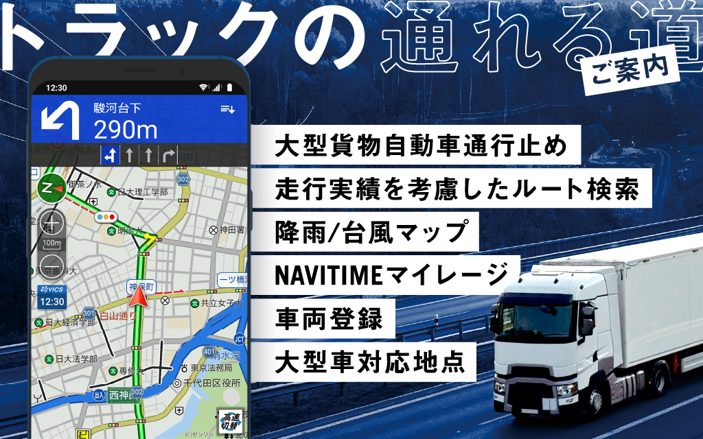
■トラックカーナビとは
日本初のトラックドライバー向けに特化したカーナビアプリ。高精度な到着予想時刻、交通規制を考慮したルート検索、複数の訪問先を効率よく回る順序の提案、大型車が駐車可能な施設の検索などが特長です。
①トラックの車両情報を登録(最大5台)
・車高 車幅 車長
・最大積載量 車両総重量
・危険物積載の有無
・高速道路料金区分
②登録した車両情報と、全国の規制情報、
交通情報を考慮してルートを検索
・大型貨物自動車の通行止め:約10.6万箇所
・車高車幅等の各種車両規制:約8.6万箇所
・最新版のゼンリン地図を利用
・交通情報(渋滞情報)にVICS、JARTICとプローブ情報(※)を利用
※NAVITIMEの各種カーナビゲーションサービスから、一日に約500万km(=地球125周分)の走行ログを蓄積。ログを分析することで、経路検索の精度を向上します
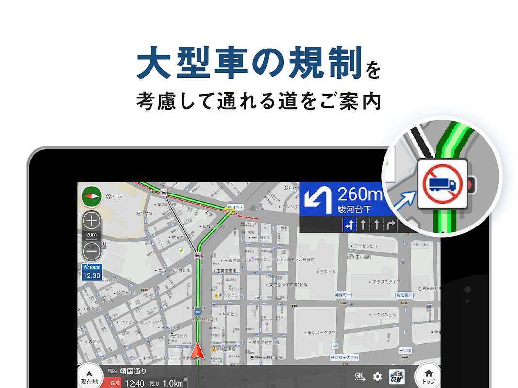
③トラックが通れる道をご案内
大型貨物車通行止めなどの各種車両規制区間を避けたルートを音声ナビゲーションします。
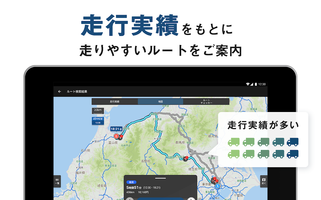
各道路の通過ユーザー数、通過時の速度など、過去の実績を考慮することで、より快適なルートを案内します。
■トラックドライバーの仕事を助ける機能が満載!
ドライブサポーターやカーナビタイムといった、ナビタイムのナビゲーションサービスを作りあげた技術をもとに、トラックドライバー向けの機能や各種データを追加し、物流や輸送などの業務利用に合った操作感を追及しました。
トラックカーナビならではの機能
【大型車規制情報の地図表示】*
登録した車両が通行できない道路区間を地図上に表示します。時間帯別の規制にも対応しています。
【巡回経路検索】*
複数の配送先や訪問先をまわる場合、最も効率的なルートをワンタップで自動計算。最適な順序を一目で確認できます。
【渋滞情報】*
渋滞状況や車線規制を地図上で確認できます。渋滞線をタップすることで、事故や自然渋滞などの詳細情報も確認できます。
【最高速度設定】
高速一般道路を走行する際の最高速度を設定できます。社内の速度規定やお好みの速度に合わせることで、到着予想時刻がより正確になります。
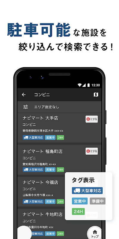
【トラックの駐車可能なスポット検索】
トラックが停車できるコンビニや道の駅、ホテルなどを絞り込んで休憩スポットを検索できます。
【フリート系SS検索】
現在地周辺からブランドを絞り込んで検索したり、地図上でアイコンを表示することができます。
〈地図上に表示できるブランド〉
エネオスウイング出光興産エネオスエッソ石油
エネクスフリート西日本フリート太陽鉱油
コスモ石油ゼネラル石油キグナス石油
モービル石油太陽石油(SOLATO)
キタセキ昭和シェル三井石油
JA-SS伊藤忠宇佐美
【Googleストリートビュー表示】
配送先の搬入口や道幅の確認に役立ちます。
【横付け設定】
目的地が左側に来るルートを検索できます。
【ゾーン30案内】*
住宅街などを避けたルートを検索します。ナビゲーション中に通過する場合、音声でお知らせします。
【3D自車位置アイコン】
地図上で現在位置を表すアイコンを、お好きなトラックアイコンに変更できます。
〈アイコンラインナップ(一部)〉
トラッククレーントラックキャリアカー
トレーラーダンプカータンクローリー
平ボディ車重機回送車ゴミ収集車
【乗降IC指定】
高速の出入り口(乗りIC、降りIC)や経由したいジャンクションを指定することで、高速利用区間を細かく設定できます。高速道路の利用区間と料金を確認しながらルートを選べるので、高速料金に制限がある方にもオススメです。
【走行実績マップ】*
トラックカーナビを利用しているドライバーの皆様が走ったルートを地図上に表示できます。土地勘のない場所へ行く際に、通過できるか不安な道を事前に走行実績があるかチェックできます。
【My地点】*
よく行く地点をMy地点としてお気に入りに登録できます。
【Myルートプラン】*
複数の目的地を回るルートを保存できます。同じルートを回る業務に役立ちます。
【つながるトラック 位置共有】
登録したパートナーの現在地や速度、到着時刻、一言に加え、実際に走行しているルート(ナビ中のみ)、走行軌跡を確認できます。
【地点共有】
つながるトラックのパートナー同士で地点情報を共有できます。待機場所や搬入出口の位置、軒下軒先情報などの有益な情報を共有する場として活用できます。
【みんなの地点】*
トラックカーナビの全ユーザーでおすすめの地点を共有できます。
【トラックログ】*
トラックカーナビを起動して走ったルートを、日別または月別に確認できます。業務の振り返りや、業務時間管理の一助として活用できます。よく確認する走行ログには名前をつけてお気に入り管理ができます。
【ログ共有】*
お気に入り管理しているトラックログをつながるトラックのパートナーに共有できます。同僚や同業者のパートナーとの間で、実績がある「通りやすい道」や「配送ルート」のノウハウ共有にご活用ください。
【ナビタイムマイレージ】
アプリをご利用中の走行距離に応じてポイントを貯められます。貯まったポイントはGポイントや3D自車位置アイコンに交換できます。
【気象情報地図】
降水量や台風の状況を全国地図で確認できます。
【ルートチェッカー】
車両情報をもとに注意すべきルートを走行前に確認することができます。
【危険地点の注意喚起】*
車両情報をもとに注意すべきポイントに近づいたときに音声でお知らせします。
■主要機能一覧
○交通情報
・渋滞線表示*
・道路交通情報*
・My交通情報エリア*
・渋滞マップ*
・高速、一般道、港などのライブカメラ
○地点検索
・フリーワード住所ジャンル電話番号
・大型車向け休憩スポット検索
・ルート沿い施設検索
○地図
・大型貨物車通行止めなどの各種車両規制区間の表示*
・ゼンリン地図
・航空衛星写真
・降雨降雪マップ
・積雪マップ
・台風レーダー
・3D自車位置アイコン
・地図情報の自動更新
○ルート検索
・巡回経路検索*
・横付け設定
・最高速度設定
・乗降IC指定
・ルート検索
├ 推奨ルート
├ 高速優先ルート*
├ 無料優先ルート*
└ 道幅優先ルート*
(渋滞考慮)*
○ナビゲーション*
・音声ナビゲーション
・ゾーン30案内
・制限速度表示
・危険地点の注意喚起
・SAPA混雑情報
└ 一部SAPAは大型車駐車場対応
○その他
・車両登録(最大5台)*
・ナビタイムマイレージ
[*]マークは有料機能(一部機能は無料利用可)
■その他情報
対応車両について
本アプリの対応範囲は道路交通法にて普通自動車、準中型自動車、中型自動車、大型自動車に分類される車両の貨物車となります。道路法による一般的制限を越える特殊車両、けん引車両には対応しておりません。
法人契約
企業で多くのドライバーが利用される場合、お得な法人契約も可能です。
詳細はこちらから
https:inquiry.navitime.co.jptruckcarnavibussiness.html?from=android_store
決済方法
会員登録は、次の決済方法に対応しています。
・ドコモspモード決済[月額700円(税抜)]
・auかんたん決済[月額700円(税抜)]
・ソフトバンクまとめて支払い[月額700円(税抜)]
・クレジットカード決済[月額700円(税抜)]
・GooglePlay決済[月額840円、年額7,800円(税込)]
└「Google Playギフトカード」での購入はできません
★初回登録に限り、各課金種別ごとに無料期間などの特典がございます
動作環境
①Android6.0以上の端末
- ご利用にあたっては、データ通信が必要となります
- 音声ルート案内は、GPS搭載端末のみでご利用いただけます
②Android5.0以上6.0未満の端末
- インストール可能なアプリバージョンは6.3.1となりますが、①と同様にご利用いただけます※
③Android4.1以上5.0未満の端末
- インストール可能なアプリバージョンは3.4.1となりますが、①と同様にご利用いただけます※
※ルート品質の改善や地図情報は、①と同様に最新版に随時更新されます
【重要】
当アプリの使用中は多くのメモリ(RAM)容量を使用するため、快適にお使い頂くためにRAM容量が大きい端末を推奨いたします。
ページが表示されない場合はお手数ですが以下の操作をお試しください。
=====
GooglePlayストア > [AndroidシステムのWebView]アプリを検索 > [アップデート]
=====
■ What is a truck car navigation system?
Japan's first car navigation app specialized for truck drivers. It features highly accurate estimated arrival time, route search that takes traffic regulations into consideration, suggesting an order to efficiently visit multiple destinations, and searching for facilities where large vehicles can park.
① Register vehicle information for trucks (up to 5)
・ Vehicle height width length
・ Maximum load capacity Gross vehicle weight
・ Whether or not dangerous goods are loaded
・ Expressway toll classification
② Registered vehicle information and national regulation information,
Search for a route considering traffic information
・ Traffic closure of large freight vehicles: Approximately 106,000 locations
・ Various vehicle regulations such as vehicle height width: Approximately 86,000 locations
・ Use latest version of Zenrin map
・ Use VICS , JARTIC and probe information (*) for traffic information (traffic jam information)
* From various NAVITIME car navigation services, we accumulate driving logs of about 5 million km (= 125 laps of the earth) a day. Improve the accuracy of route search by analyzing logs
③ Guide the way the truck can pass
Voice navigation is provided on routes that avoid various vehicle-restricted sections such as large freight vehicles.
We will guide you to a more comfortable route by considering past achievements such as the number of users passing through each road and the speed at the time of passing.
■ Full of functions to help truck drivers work!
Based on the technology that created the navigation service of Navitime such as drive supporter and car navigation time, added functions and various data for truck drivers , suitable for business use such as logistics and transportation. We pursued a feeling of operation.
Functions unique to truck car navigation systems
[Map display of large vehicle regulation information] *
The road sections that the registered vehicle cannot pass are displayed on the map. It also supports time zone regulations.
[Circuit route search] *
When visiting multiple delivery destinations or visit destinations, the most efficient route is automatically calculated with a single tap. You can check the optimum order at a glance.
[Congestion information] *
You can check the traffic condition and lane restrictions on the map. By tapping the traffic jam line, you can also check detailed information such as accidents and natural traffic jams.
[Maximum speed setting]
You can set the maximum speed when driving on highways general roads. Estimated arrival times will be more accurate by adjusting to your company's speed regulations and your preferred speed.
[Search for parking spots on trucks]
You can search for break spots by narrowing down convenience stores, roadside stations, hotels, etc. where trucks can stop.
[Fleet SS search]
You can narrow down the search by brand from around your current location and display icons on the map.
Eneo Swing Idemitsu Kosan Eneos Esso Oil
Enex Fleet West Japan Fleet Solar mineral oil
Cosmo Oil General Oil Kygnus Oil
Mobile Oil Taiyo Oil (SOLATO)
Kitaseki Showa Shell Mitsui Oil
JA-SS Itochu Usami
[Google Street View display]
It is useful for checking the delivery entrance and road width.
[Horizontal setting]
You can search for routes where your destination is on the left.
[Zone 30 guide] *
Search for routes that avoid residential areas. If you pass during navigation, you will be notified by voice.
[3D vehicle position icon]
You can change the icon that shows your current position on the map to your favorite track icon.
Truck crane truck carrier car
Trailer dump truck tank lorry
Flat body vehicle heavy equipment forwarding vehicle garbage truck
[Getting on and off IC designation]
By specifying the high-speed entrance (boarding IC, getting-off IC) and the junction you want to go through, you can set the high-speed usage section in detail. You can choose the route while checking the section of the expressway and the toll, so it is also recommended for those who have restrictions on the toll.
[Driving record map] *
The route taken by the drivers using the truck car navigation system can be displayed on the map. When you go to a place where you don't know the land, you can check in advance if you have a track record of driving on uncertain roads.
[My point] *
You can register frequently visited points as My points in your favorites.
[My route plan] *
You can save routes that go around multiple destinations. It is useful for work that goes around the same route.
[Connected track location sharing]
In addition to the registered partner's current location, speed, arrival time, and a word, you can check the route you are actually traveling (only during navigation) and the travel trajectory.
[Point sharing]
You can share location information between connected truck partners. It can be used as a place to share useful information such as waiting place, location of carry-in exit, eaves eaves information.
[Everyone's point] *
All users of truck car navigation can share recommended points.
[Track log] *
You can check the route you ran by starting the truck car navigation system by day or month. It can be used as an aid in reviewing work and managing business hours. You can name the driving logs you check often and manage them as favorites.
[Log sharing] *
You can share the track log managed by Favorites to the partner of the connected track. Please use it to share know-how on "easy-to-pass" and "delivery routes" that have a proven track record with colleagues and partners in the same industry.
[Navitime Mileage]
You can earn points according to the mileage while using the app. The accumulated points can be exchanged for G points or 3D vehicle position icons.
[Weather information map]
You can check the precipitation and typhoon conditions on a national map.
[Route checker]
You can check the route to be careful of based on the vehicle information before driving.
[Caution for dangerous spots] *
Based on the vehicle information, you will be notified by voice when you approach a point to be noted.
■ List of main functions
○ Traffic information
・ Congestion line display *
・ Road traffic information *
・ My traffic information area *
・ Traffic jam map *
・ Live cameras for high speeds, general roads, ports, etc.
○ Point search
・ Free word address genre phone number
・ Search for break spots for large vehicles
・ Facility search along the route
○ Map
・ Display of various vehicle regulation sections such as large freight vehicles closed *
・ Zenrin map
・ Aviation satellite photography
・ Precipitation snow map
・ Snow map
・ Typhoon radar
・ 3D vehicle position icon
・ Automatic update of map information
○ Route search
・ Patrol route search *
・ Horizontal setting
・ Maximum speed setting
・ Boarding alighting IC designation
・ Route search
├ Recommended route
├ High-speed priority route *
├ Free priority route *
└ Road width priority route *
(Consideration of traffic congestion) *
○ Navigation *
・ Voice navigation
・ Zone 30 information
・ Speed limit display
・ Caution for dangerous spots
・ SA PA congestion information
└ Some SA PAs are compatible with large car parking lots
○ Others
・ Vehicle registration (up to 5) *
・ Navitime Mileage
[*] Mark is a paid function (some functions can be used for free)
■ Other information
Compatible vehicles
The scope of this application is freight vehicles that are classified as ordinary vehicles, semi-medium-sized vehicles, medium-sized vehicles, and large-sized vehicles according to the Road Traffic Act. We do not support special vehicles and towing vehicles that exceed the general restrictions imposed by the Road Law.
Corporate contract
If many drivers are used in a company, a good corporate contract is also possible.
Click here for details
https:inquiry.navitime.co.jptruckcarnavibussiness.html?from=android_store
Payment method
Membership registration supports the following payment methods.
・ DoCoMo sp-mode payment [700 yen per month (excluding tax)]
・ Au simple settlement [700 yen per month (excluding tax)]
・ SoftBank collective payment [700 yen per month (excluding tax)]
・ Credit card payment [700 yen per month (excluding tax)]
・ Google Play payment [monthly fee 840 yen, annual fee 7,800 yen (tax included)]
└ Cannot be purchased with "Google Play Gift Card"
★ Only for the first registration, there are benefits such as a free period for each billing type
Operating environment
① Android 6.0 or higher device
――Data communication is required to use
--Voice route guidance is available only on GPS-equipped terminals.
② Devices with Android 5.0 or higher and less than 6.0
--The installable app version is 6.3.1, but you can use it in the same way as ① *
③ Devices with Android 4.1 or higher and less than 5.0
--The installable application version is 3.4.1, but you can use it in the same way as ① *
* Route quality improvements and map information will be updated to the latest version as in ①.
[Important]
Since a lot of memory (RAM) capacity is used while using this app, we recommend a terminal with a large RAM capacity for comfortable use.
If the page is not displayed, please try the following operations.
=====
Google Play Store> Search for the [WebView on Android System] app> [Update]
=====
What's New
★ Ver 6.4.0を公開しました(2020/12/07)
■ログ共有
自分の走行実績であるトラックログをパートナーへ共有できるようになりました。
共有するログは名前や車両情報を付けてお気に入りとして管理するため、お一人でのご利用でもログの確認が手間なくできるようになりました。
※このバージョンを含む今後のアップデートはAndroid OS 6.0以上の端末でご利用可能となります
※「ログ共有」はAndroid先行対応です
その他、改善、アプリの内部処理に関わる不具合の改修を行いました。
Latest Version (Download)
トラックカーナビ by ナビタイム 大型車,渋滞情報,交通情報,通行止め,地点共有,ライブカメラ 6.3.1Date Updated : 2020-12-19
Advertisement
